Before examining issues related to the boundary plan, you should understand what it is. A land plot plan is a document drawn up on the basis of a real estate property or a similar registry extract. This document is also prepared on the basis of information entered into a unified state database or new information obtained during measurements and determination of boundaries.
Planning, surveying and production of a boundary plan is a whole set of land management procedures, including geodetic work. They are carried out to establish, restore, and also strengthen clear boundaries of the territory, the total area and its location. The preparation of a boundary plan occurs after all procedures have been completed and is of a technical nature. It is impossible to obtain a boundary plan without registering the land plot on the state register. Information entered into a single database must be identical to the document.
Due to the fact that most owners received a land plot many years ago and did not carry out the land surveying procedure afterwards, their property has conventional boundaries, and if it is necessary to make any transaction, the presence of a clear boundary is mandatory.
Dear readers!
Our articles talk about typical ways to resolve legal issues, but each case is unique. If you want to find out how to solve your specific problem, please contact the online consultant form on the right →
It's fast and free!
Or call us by phone (24/7):
When should you apply?
It is necessary to obtain a new land surveying plan with the entry of changed data into the cadastral registration database in the following cases:
A boundary plan can be obtained only on the basis of information from the cadastral plan and information entered by Rosreestr into the unified state database of property rights. In some cases, cartographic materials and land management documents may be used, which are stored in the archives of the state fund created on the basis of all previous land surveys.
Certificate of approval and basic information
Russian legislation, led by federal laws on the state cadastre, establishes that the preparation of a plan for the distribution of land boundaries must be carried out exclusively by qualified specialists and with the involvement of the owners of neighboring plots. The selection of a cadastral engineer must take place at a meeting of all interested parties. After the participants come to a general agreement, an act of approval of the location of the land plot for which the plan will be drawn up should be concluded. The finished plan must be certified by the signature of the cadastral engineer and the seal of the organization to which it belongs.
When accepting a completed land survey plan, the owner of the land plot must check the presence and correctness of the following information:
- About the property formed during the division or redistribution of the territory;
- About the land plot, which was formed from state and municipal forms of ownership;
- About the land for which cadastral registration information is being corrected or clarified.
What documents are issued after land surveying?
- You contact an engineering and geodetic company in your city, which must have a good reputation among clients (in Saransk, this includes Cadastral Center LLC) and enter into an agreement for land surveying.
- You collect the necessary package of documents and notify your neighbors whose land plot borders yours about the land survey.
- The engineers of the geodetic company carry out all the necessary measurements, fix the boundaries and draw up a survey report.
- The number of documents that you will receive after land surveying includes the so-called land surveying file. You must be given 2 copies: one document remains in your hands after land surveying, and the second is submitted to the cadastral chamber to assign a cadastral number to the plot.
Land surveying is an integral process of registering it as property and registering it with the cadastral register. The essence of surveying is that a specialist who has a license for geodetic and cartographic surveys establishes and secures the boundaries of the site on the ground. After all the necessary documents have been prepared and the plot has been registered with the cadastral register, its owner will receive the documents after land surveying and will be able to carry out a full range of actions with his property such as purchase and sale, will, gift or exchange.
Plan Structure
The boundary plan of a real estate property has a structure common to all similar documents and consists of two main parts, containing not only a textual, but also a graphic part. The structure looks like this:
| The grafical part | Displaying information about a specific land plot for which cadastral registration and documentation data is available. The boundaries of the territory are also graphically indicated here, with clarification of the boundaries with neighboring real estate objects. It is important that in this part all approaches and access to the formed land territories are noted, including vehicle access routes and public areas |
| Text part | The text includes all data that is also entered into the cadastral registration database to the extent established by the responsible institution and legal regulations regarding the state registration of real estate. The land survey plan must contain approval acts. All work carried out to measure and determine boundaries is paid by the owner who submitted the application to the specialists. The cost of the service will depend on the location, area and additional services |
Why is land surveying necessary?
- make an exchange transaction, donate a plot, inherit or inherit, mortgage it, etc.;
- divide the site into several for different purposes;
- combine adjacent areas;
- legitimize the existing territory or clarify its parameters (due to doubts or disputes with neighbors);
- design a building on this territory;
- restore boundaries that are missing on the general plan (this is especially important for land owners in SNT).
As a result, people apply for land surveying in cases where a new plot has been obtained or there is a desire to clarify the boundaries of an existing one. Based on the survey results, the customer is provided with documentation. This can be used to enter a plot of land into the cadastral register and register rights to it, or to make changes.
Documents for land surveying
To order and receive a boundary plan, the owner of a property contacts a specialized institution that deals with issues of surveying, distribution of boundaries and carrying out land management work. Drawing up a project requires the presence of certain skills and knowledge of legislative norms, so it is carried out only by a qualified specialist - a cadastral engineer.
The procedure will be carried out on the basis of the documents that were submitted along with the application. If we are talking about a legal entity, then it must have the right to engage in activities related to geodetic and cartographic work.
You can order and receive a boundary plan not only in paper form, but also in electronic form. To do this, the following documents are attached to the application:
- Certificate of ownership of the property, as well as other title documents;
- Extract from the unified state registration database of property rights;
- Applicant's passport;
- Technical documentation from the Bureau of Technical Inventory on the absence or presence of buildings;
- Cadastral plan or extract.
How to make a land survey
A cadastral engineer employed by a self-regulatory organization is hired to carry out the work. All specialists can be checked in the register. Here you can find information on refusals to register objects that followed after the survey was completed by an engineer. It is also recommended to pay attention to the work experience of such specialists and read reviews about their work.
The land surveying process consists of various activities:
- Preparation in the form of assembly and study of title, geodetic, and other documentation.
- Field study of the site and assessment of boundary signs.
- Formation of a technical project for land surveying.
- Informing neighbors about planned work.
- Coordination of boundaries with neighboring properties and securing them in real conditions using special signs.
- Identification of coordinates of compulsory medical insurance points and boundary markers.
- Measurement of land ownership area.
- Sketching a drawing along the boundaries.
Upon completion of the cadastral engineer’s work, the customer receives text documents and graphic images of the site. The work will take more than one day. From the moment the contract is concluded, the total period will last up to 30 calendar days (not business days).
If customers of services are dissatisfied with the result of the survey, they have the right to appeal against the actions or inactions of responsible persons in pre-trial proceedings or when filing a claim. In the first case, you are allowed to contact the BTI directorate, the deputy mayor of the city. A response to the appeal will be received within a month.
Cadastral errors
If errors are identified in cadastral registration information and there is a need to enter missing or changed information, there is no need to submit an additional application and re-collect documents. The location of a land plot and its boundaries will be considered agreed upon by law only if there is an approval act, which contains all the signatures of interested citizens and organizations or their representatives.
If it is necessary to correct a cadastral error, as well as the formation of a new land plot, one boundary plan should be drawn up, without a preliminary application, but always with an approval act.
Correcting a cadastral registration error is considered necessary if the layout of the property differs from the layout in the unified state database on the basis of which title documents are issued. Recording and correction by a cadastral engineer on a document is not a correction of an error or justification for a clear clarification of the boundaries of the territory. The boundary plan will have to be redone and the data entered into the cadastral registration database.
Dear readers!
It's fast and free!
Or call us by phone (24/7).
Today, many Russians own land. But not everyone knows how to properly prepare documents for it.
One of the papers associated with a land plot is its boundary plan.
This is an explanation and justification of the calculations and measurements made, as well as the results obtained based on them.
A conclusion is required if:
- Differences were identified in the actual location of the boundaries and those indicated in.
- In cases where it was carried out.
- It is possible in other cases as decided by the cadastral engineer.
You can try to challenge such a refusal in court, but it will take longer and be more expensive.
Graphic
The graphic part contains:
- the land plot(s) being formed;
- diagrams of sites that previously existed;
- drawings of sites and access roads;
- outlines of plot boundaries.
All diagrams and drawings are made using standard designations of boundaries, points and other objects. Signatures for them are also made in the same style.
What documents are issued after land surveying?
The above authorities have sample applications that you can use. If you are preparing a document in advance, bring it with you and provide it along with the original documents. After verification, the employee of the competent authority leaves copies of them.
- identification document;
- notarized power of attorney if you are a representative;
- title documentation for the land (certificate of state registration or extract from the Unified State Register of Real Estate);
- document providing the basis for the emergence of land tenure rights (agreements, certificates, decisions and resolutions of the municipality, etc.);
- cadastral passport for the original plot, if it is not newly formed;
- act of approval of boundaries (if required).
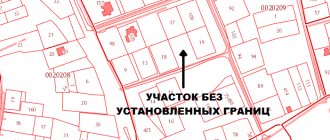
Photo of the document
You can see what some pages of the graphic part of the boundary plan look like in the photo below:
The following notations are accepted:
- The boundaries are determined by lines, with those that existed before the cadastral work drawn in black, and those that appeared in red.
- A solid line is used for boundaries whose location is determined with sufficient accuracy, and a dotted line - with insufficient accuracy.
The thickness of the lines is also regulated - 0.2 mm. The length of the dotted line is 2 mm, the distance between them is 1 mm.– an important document containing a lot of information about the land plot. It must be properly drawn up both when the site is formed and with any changes to its boundaries.
See inaccuracies, incomplete or incorrect information? Do you know how to make an article better?
Would you like to suggest photos on the topic for publication?
Please help us make the site better!
Leave a message and your contacts in the comments - we will contact you and together we will make the publication better!
A boundary plan of a land plot is a document drawn up on the basis of information from the cadastral plan of the territory or a cadastral extract about the land plot. It must reproduce complete and reliable data entered into the state real estate cadastre and indicate information about the formed plot of land, or about its part.
The boundary plan is used to carry out cadastral work, the result of which is the preparation of documentation for submission to the cadastral registration authorities with subsequent entry of data into the register of real estate.
Compound
Let's consider the structure of the boundary plan.
The grafical part
It reproduces data from the cadastral plan of the desired territory: the location of the boundaries forming the land plot is indicated, these boundaries and access to the land are specified (pedestrian or motor roads from public areas). Using the graphical part, you can get an idea of what the boundary plan of the land plot looks like.
Text part
This section of the document specifies the information necessary to enter the land into the state real estate cadastre. The scope of this information is established by the regulatory authorities of cadastral relations and the Federal Law “On the State Real Estate Cadastre”.
Defining boundaries
- To determine the exact location of the boundaries, the coordinates of their characteristic points are determined - the places where the earth is divided into parts and where the angles change.
- The location of boundaries is determined in accordance with the procedure determined by the authorities regulating the sphere of cadastral relations.
- In accordance with existing standards, the area of a plot of land is considered to be the area of a geometric figure, which is formed by projections of the boundaries of the plot on a horizontal plane.
- To clarify the boundaries of a site during land surveying, information is used that is in the title documents or in the documents in accordance with which the boundaries were determined when the site was formed.
- If the specified documentation is missing, the boundaries are recognized as those that have existed in the area for more than fifteen years and are fixed by natural objects or objects of artificial origin that make it possible to accurately determine the location of the boundaries.
When is a boundary plan needed?
It is necessary to obtain a land survey plan, the cost of which varies depending on the company providing survey services, the location of the land and other factors, in the following cases:
- when a land plot is formed by association;
- when formed as a result of partition;
- when formed from lands;
- as a result of discharge;
- when dividing with a modified land plot;
- during land redistribution;
- when dividing into parts;
- if necessary, clarify information from the state cadastre: area and/or boundaries.
Why do you need a land survey plan, how to prepare it and how much will it cost?
Land surveying is a set of engineering and geodetic works aimed at determining the boundaries of a land plot in the horizontal plane. As a result of such work, the cadastral engineer draws up a boundary plan.
A boundary plan is a mandatory technical document for each owner of a land plot, drawn up on the basis of a cadastral plan and survey results or on the basis of a cadastral extract of a given land plot.
IMPORTANT! Only specialized firms and certified cadastral engineers have the right to carry out work to establish boundaries and draw up a plan for a land plot.
Main differences from the land boundary plan
A boundary plan and a boundary plan are two completely different documents.
The boundary plan reflects the current boundaries of the land plot, their features, and length.
The boundary plan reflects the very process of forming a given area with the help of lines, arrows, dotted lines and other symbols. The graphic images of these two documents are completely different from each other.
Differences from the cadastral plan
These two documents, unlike the boundary plan, are similar to each other. But you should not confuse them, since these are also two different documents. The boundary plan is a kind of continuation of the cadastral plan.
The cadastral document is taken as a basis and then further changes carried out with the land plot (merger or delimitation) are schematically depicted on it.
That is, it reflects further changes in the cadastral plan and supplements it.
Differences from technical
Although these two documents are also similar, they have several differences:
- the technical plan displays not only the boundaries of the land plot, but also all the buildings located on it;
- To draw up a technical plan, title documents for buildings, operating permission, etc. are required. While in order to draw up a land survey, you need data from the cadastral passport.
Types of MP: what is it for?
According to land legislation, there are 7 types of such plans:
- Specifying the boundaries and area of the site. Such a plan is drawn up in the case when the state cadastre does not have enough information about the exact location of the site (its boundaries, inaccurate coordinates of turning points, etc.).
- Specifying the location of lands on the territory in the event that the site was allocated from state and municipal lands.
- Providing information about the site formed as a result of the allocation of shares from land holdings that are in shared ownership.
- Reflecting the merger of areas, when several were combined into one.
- Reflecting information on the redistribution of land plots.
- To correct cadastral errors.
- To reflect information about areas formed as a result of divisions.
Registration procedure
- It is necessary to conclude an agreement with a licensed geodetic company, which will specify the terms and cost of the work.
- Prepare and provide all requested documents to the geodetic organization and inform neighbors about the upcoming land surveying procedure.
To avoid controversial issues regarding boundaries, it is better for neighbors to be present during land surveying. - After the survey, a draft copy of the survey plan is drawn up, signed by the owner of the site, neighbors, engineer and an authorized person representing the interests of the administration.
- On the appointed day, pick up the finished plan from the geodetic organization.
In the event that the boundaries of the site have been changed, the plan must be approved by the land resources committee and a state fee of 1,000 rubles must be paid.
IMPORTANT! In the case of shared ownership of a plot, all shareholders must take part in the land surveying process.
Compilation deadlines
Preparation time depends on many details. Receipt can take on average from two weeks to one month. In this case, the longest stage is the approval of the boundaries of the site.
This takes from 5 to 30 days.
But organizations involved in the land surveying process usually do not announce the exact deadlines for drawing up, since in some cases, for many reasons, the process can drag on for even a month.
Price
Due to the large labor costs, the cost of land surveying is high. It also varies by region. In cities of federal significance, surveying a plot of up to 1 hectare will cost 35-50 thousand rubles. This cost includes the amount of labor intensity and standard hours (salary of a cadastral engineer). Labor intensity is taken from the table of types of work performed and factors of its complexity.
Structure: what parts does it consist of?
All types of boundary plans consist of a graphic and text part.
The graphic part reflects:
- site diagram on the ground;
- site boundaries;
- drawing with information about the area and other indicators;
- location of all buildings and geodetic objects.
The text part reflects the following information:
- initial data;
- on the approval of boundaries;
- about neighboring areas;
- conclusion of a cadastral engineer.
FOR REFERENCE! The boundary plan is prepared on paper and electronic media. The electronic form must be protected by a digital signature of the cadastral engineer.
MP sample
Source: https://georeestr.com/zemelnyj-uchastok/kadastrovye-raboty/mezhevanie/mezhevoj-plan.html
Stages of work
Let's consider step by step how the plan is drawn up.
- First, the specialist studies the title and other source documents.
- Then the condition of the supporting boundary network is assessed and its field survey is carried out.
- A field survey of the land boundaries is being carried out, coupled with an assessment of the condition of existing boundary signs.
- A technical survey project is being drawn up.
- The boundaries are agreed upon with the owners/users of adjacent plots of land.
- The coordinates of the reference network points and land survey signs are determined.
- The specified areas are determined.
- A plan (map) of the boundaries is drawn up.
- Materials are collected and the boundary plan itself is formed.
- The survey materials are approved by the cadastral chamber department.
Required documents
Where can I get a land survey plan? To draw up this document, you can contact organizations that provide similar services. They will give you a ready-made boundary plan. If you plan to organize the work yourself, you will take the finished document upon completion of the procedure from the cadastral registration authorities.
What papers are needed:
- application requesting work to be performed;
- a copy of the applicant’s identity card or a copy of the power of attorney of his representative, certified by local authorities;
- a document of title that is the basis for ownership of land: a gift agreement, a purchase and sale agreement, a certificate of inheritance by law/will, and others;
- certificate of state registration of rights;
- original documents from the BTI for buildings located on the site;
- certificate confirming the absence or presence of connected communications;
- cadastral extract;
- extract from the Unified State Register for preparing a description.
Upon completion of all necessary work and activities, you will receive a boundary plan, which must be signed by the cadastral engineer who was involved in the preparation and production of the document. Be sure to check the presence of all the necessary information about the land plot: area, exact boundaries, etc.
In accordance with the Federal Law of the Russian Federation “On the State Real Estate Cadastre”, clause 1, article 38, a boundary plan is a document for the preparation of which is the basis. In addition, the basis for drawing up a land survey plan can be a cadastral extract about a specific land plot. These documents must reproduce the information reflected in the state cadastre of real estate and indicate the necessary information about the newly formed plots of land or parts of the land plot. If additional information appears about any land plot, it must be entered into the state cadastre of real estate.
A boundary plan is required when submitting the following applications to the cadastral registration authority:
- Applications for cadastral registration of one or more land plots;
- Applications for amendments to a land plot;
- Applications for registration of part of the site.
In accordance with the Law “On the State Real Estate Cadastre” Ch. 4 the preparation of a land survey plan is carried out as a result of the implementation of cadastral work, which in turn is done by a cadastral engineer on the basis of a concluded contract for carrying out cadastral work.
It should be noted that until 01.01.2011, on the basis of the Federal Law, Art. 44 cadastral activities could be carried out by persons who, before the law came into force, had the right to carry out land management work. The boundary plan document is certified by the signature of the cadastral land surveyor who was involved in the preparation of this document, and the seal of the geodetic organization.
Coordination of site boundaries
The boundary plan must necessarily contain information on the coordination of the location of plot boundaries in cases where the latter is mandatory. The position of the boundaries of individual plots of land is subject to mandatory approval in the case of cadastral work, during which documents are prepared for submission to the cadastral registration authority on changes to one or more land plots that were identified in connection with clarifying the location of boundaries with persons having adjacent land plots.
To do this, two days before carrying out geodetic work, the owners of adjacent lands must be notified of the upcoming work by notices in a specially established form. These notices are prepared by a land surveyor of the organization carrying out land surveying work.
The agreement or disagreement of the owners bordering each other on the boundaries of land plots is recorded in the executed act on the establishment and approval of boundaries. This act is signed directly by the owners of adjacent plots of land or their representatives, as well as by a land surveyor, who certifies the survey with the seal of a geodetic organization, and by a land surveyor of the city or village administration, who also certifies the document with the seal of the administration.
In the event that one or several owners of lands with adjacent boundaries refuse to coordinate the boundaries, this must be recorded in writing in the act of approving the adjacent boundaries with a mandatory indication of the reason. Any disagreements that arise are resolved administratively or in court.
Required documents for land surveying for individuals
1. Application for work (submitted to the land management geodetic organization). 2. Photocopy of the customer’s passport (copy of the representative’s power of attorney). 3. Certificate of ownership of the allocated land plot. 4. Resolution of the administration on the provision of ownership of a land plot. 5. Copying to the site. 6. Cadastral passport. 7. Cadastral plan.
Documents confirming the fact of land surveying: which ones are issued and what they look like
In the process of establishing the boundaries of the plot, the engineer carries out a list of works aimed at accurately calculating the turning points of the plot and determining its boundaries - a contour line that clearly designates the area to which the land owner's property rights will subsequently extend.
As a result, all data is entered into the final document - boundary plan , which is handed over to the customer at the end of the process.
Changes in legislation
The legislation of the Russian Federation periodically undergoes a number of changes, and acts relating to cadastral activities and the conclusion of civil legal acts are no exception.
Thus, starting from January 1, 2021 , an innovation came into force that affected all owners of plots located in the Russian Federation.
Currently, any conclusion of purchase and sale transactions, donations of land, exchange of one plot for other objects and other agreements resulting in the alienation of plots have become impossible without a plan and, as a consequence, without first carrying out the land surveying procedure.
In this regard, the need for drawing up such plans has increased significantly.
In addition, taking into account the required time to draw up a document and carry out mandatory measures, the customer receives a finished plan within a period of 3 to 6 months , so all land owners began to order boundary work, so that, if necessary, they would not waste time collecting the necessary documents and waiting for completion .
In parallel with this, it is worth taking into account the fact that currently registering a land plot requires the provision of a certain list of documentation, among which, in particular, is a boundary plan.
What is a boundary plan
At its core, a boundary plan is a list of information about a site , which is based on an extract from the Unified State Register of Real Estate about the allotment; it also indicates other data that was obtained by the engineer based on calculations and information determined during a direct visit to the location of the allotment.
This document contains the following information :
- A graphic representation of the land plot indicating the turning points, when drawing lines through which the boundaries of the plot are directly formed;
- A list of information required to provide regarding the land plot, defining its main characteristics, owner and parameters that distinguish it from the general mass;
- Data that has been changed in relation to previously established boundaries and boundary plans drawn up before the work was completed.
- Conclusion of the cadastral engineer on the specifics of the work with reference to legislative acts, if necessary;
- An indication of the approval procedure, which confirms that all persons or organizations whose rights could be affected in determining the location of the boundary have approved the location of the boundary.
The structure of the plan is primarily divided into text and graphic parts. The textual one, in turn, is presented directly with information on the land plot, an engineer’s conclusion, and an act of approval of boundaries.
Below we will attach samples and photos of the document so that readers can see what it looks like.
Forms in PDF format can be found here.
Forms in PDF format can be found here.
Text part
The text part contains the main information characteristics of the land plot and includes the following data :
- Initial indicators on the basis of which the engineer made calculations;
- Data on what measurements and calculations were made during the process of drawing up the document;
- Data on what areas or parts of areas were formed or what changes were made to them (if any);
- Data on those plots that allow access to this site;
- Conclusion of the specialist who drew up the plan;
- An approval act signed by all interested parties (owners of adjacent plots).
Conclusion
The conclusion began to be included in the document starting in 2008 as a section of its text part.
Initially, this part of the plan was a special explanation, justification for the work carried out and how the border defining the area of the site runs.
Since 2012, such a part began to be included when necessary and it is drawn up to describe the actions performed.
It is used in situations where the definition of boundaries or any actions in the process of their installation require reference to legislative acts or certain facts to prevent the recognition of boundaries as invalid or illegally established.
Border approval act
Most of the land plots for which the specialist determines the boundaries in the process of drawing up the plan have adjacent plots directly adjacent to it.
In such situations, in order to ensure that the rights of the owners of such plots are not affected, a procedure for their approval becomes necessary.
To do this, a general meeting is held , at which the engineer presents a previously drawn up plan and clearly explains how the boundaries of the site will be drawn.
If there are no contradictions, all interested parties sign a separate document.
If all areas (or some) previously had approvals for passing boundaries, such an act may not be available .
The grafical part
The graphic part of the boundary plan is a direct display of the passing boundaries of the site, defining the boundaries of the property of a person or organization and it contains the following :
- Object diagram;
- Location of the site taking into account the accepted display scales;
- The drawing itself of the site and its parts (if there is a need to highlight the components);
- Outlines of the nodal (turning) points of the allotment, between which there are lines defining the boundaries of the property.
In what formats is it issued?
The plan is presented first on paper . The document is executed in two original copies, one of which is received by the direct customer.
Currently, in parallel, the engineer is also preparing an electronic version , which, if desired, can be separately provided to the customer who has entered into a contract for boundary work.
What to do after the procedure
After surveying and receiving the plan, owners can apply to register their plots and receive (or update) a document confirming ownership.
Collection of documents
The procedure for applying to Rosreestr in one of the possible ways is accompanied by the preliminary collection of the necessary documentation, which includes :
- Applicant's passport;
- Power of attorney, in the event that the application is not from the direct owner, but from an authorized representative;
- A document confirming ownership of the plot;
- The document that became the basis for the emergence of property rights;
- Certificate of approval (if necessary);
- Cadastral passport.
Drawing up an application
To register an allotment, you will first need to draw up an application - it is on its basis that Rosreestr employees will consider the possibility of entering information about the allotment into the general database.
So, the statement states the following :
- The organization to which the application itself is directly sent;
- Document type;
- The number of extracts from the unified register that the applicant will need;
- Information about who is the direct applicant;
- List of documentation that is provided along with the application;
- How does the applicant wish to receive documents;
- The date on which the document was drawn up and the signature of the person submitting it.
Submission of the application and the required list of documents is carried out through one of the possible methods - through a personal visit to Rosreestr or MFC, sending an application by mail or sending it via the Internet.
Personal reception
Submitting an application through a personal appointment can be done by directly visiting a Rosreestr branch or any of the branches of the Multifunctional Center.
When submitting documents directly to Rosreestr, the applicant will receive a response to his application as soon as possible .
Thus, registration is carried out within just 5 days, registration of property rights is carried out after 7 days, and joint registration of ownership and registration is completed within 10 days.
Mailing
It is recommended to send an application by mail exclusively by registered mail and in no case send the originals of existing documents in this way - only copies .
However, this method is used only if it is impossible to submit an application in person, since the mandatory period is counted from the moment the letter is received by an employee of the Rosreestr department.
Through the Internet
The method of submitting an application via the Internet is the most convenient, since it does not require personal presence , and the existing system for filling out the application allows you to avoid entering data incorrectly.
To submit documents, you will need to go to the official website of Rosreestr and go to the application submission section, where you fill out all the fields contained therein.
Where in the extract from the Unified State Register does it say about boundary work?
An extract from the Unified State Register, which is provided after the site is registered, is a list of information from two combined databases - the Unified State Register and Cadastral Registration.
Such an extract replaces the provision of a certificate of registration of ownership, a passport of the allotment and a certificate of its price .
The extract includes data contained in three sections:
- Characteristics of the site - exact address, size (area), category of use, number in the cadastre database, as well as other basic parameters;
- Information about the person or organization that is the owner of the site . The presence of any encumbrances that exist regarding actions with the site (for example, if it is collateral), data on the seizure or emergence of the right to own it are indicated;
- The grafical part . It directly displays a diagram showing the delineation of the allotment, that is, an indication of how its border directly passes. The address of the site is also indicated and the route of utilities is stated.