Land surveying is often the first step towards registering ownership of a land plot. Purchasing land and houses already requires large investments. Against this background, any additional expenses may seem like an unnecessary burden. Therefore, when starting cadastral work, land users want to know what they will have to pay for and whether there is a state duty for surveying a land plot in 2021.
This article will tell you whether such an expense item exists and what you still have to spend money on.
Determining the boundaries of the garden plot
The delineation of a garden plot is carried out according to the same rules as for other land plots. The only difference is that the documents often contain confusion, since some issues are resolved by the SNT Board.
Another difference: when agreeing, sometimes it is not enough to obtain the consent of neighbors of adjacent plots, but a general meeting of all members of the gardening association is required.
What it is?
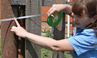
Landmarking a garden plot is the precise determination of the coordinates of its boundaries.
Such work is carried out by specialists, cadastral engineers, who go to the site to carry out geodetic work.
The next step is to coordinate the boundaries of the site with the neighbors and prepare a boundary plan, where all calculations are entered.
This information is submitted to Rosreestr and undergoes state registration .
Boundary work on garden plots is carried out less frequently than on lands for individual housing construction (IHC). This is due to the fact that in order to build a residential building (the main purpose for individual housing construction), it is necessary to survey the site.
The legislative framework
The land surveying procedure in garden plots is regulated by several laws :
- Federal Law of the Russian Federation No. 221 (adopted in 2007) systematized cadastral registration. It takes into account all the nuances of the work of cadastral authorities from A to Z.
- Federal Law of the Russian Federation No. 447 (adopted in 2014) amended the first law. The most important of them were: streamlining the correction of errors and the introduction of comprehensive cadastral work (including when surveying garden plots).
- Federal Law of the Russian Federation No. 93 (adopted in July 2006) “On the issue of registration of real estate in a simplified manner” or the so-called “dacha amnesty”.
All three laws directly relate to land surveying of summer cottages .
Is it necessary to do it?
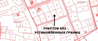
Land surveying of a garden plot received before 2001 is not necessary . This is how we can briefly convey the meaning of the dacha amnesty for the privatization of the plot. According to it, the owner of a dacha plot allocated by the state registers ownership according to a simplified scheme.
The package of documents does not include a boundary plan; only the most necessary data is entered into the state cadastre. The site is listed as having “undefined boundaries .
Is there a state duty for land surveying?
Today, neither the Tax Code of the Russian Federation nor other regulations of the Russian Federation provide for a separate fee for land surveying.
To carry out land surveying, a civil contract is concluded between the land user and the organization providing land surveying services. According to the norms of the Civil Code of the Russian Federation, the responsibility for paying for services lies with the customer of the work or another person specified in the contract. In the case of a land surveying contract, most often these are the owners or tenant of the land plot.
The contract also stipulates the cost of services that the customer will have to pay. In this case, the owner of the land plot does not have to make any additional payments to the state.
Land users can receive these services completely free of charge as part of comprehensive cadastral work in accordance with Law No. 447-FZ of December 22, 2014. In this case, the agreement is concluded by the municipality with the selected organization. In this case, the customer of the work is the local administration, and it cannot demand compensation from the land owner.
Attention! Such work is financed from the money included in the federal target program and the owner will not incur any additional costs directly for land surveying in this case.
Not everyone has the opportunity to do land surveying for free. Land owners who:
- Are not registered with Rosreestr or the legal requirements for their description therein are not met;
- Located under public areas, including beaches, water bodies, buildings and structures;
- Occupied by buildings, objects and structures, including those under construction, provided that the rights to them are legally registered.
How to do it?
Before surveying, you need to collect all the necessary documents. To guarantee quality work, you need to find out which cadastral engineers you can contact in your region.
A contract is concluded with the selected company . But before that you need to collect all the documentation and write an application.
Documentation
To survey a garden, you need the following package of documents :
- statement;
- applicant's passport;
- title documents (they explain how the land plot came to you), this could be a decree on the allocation of land;
- Certificate of ownership and cadastral passport (if available);
- SNT land surveying project;
- site diagram.
If any documents are missing, then you need to contact the SNT Board, Rosreestr or the archive of the locality.
SNT territory survey project
A survey project is a cadastral document that describes the boundaries of the territory from which shares are allocated. It has text and graphic parts.
The land survey project precedes the division of a large plot (cadastral block) owned by SNT into smaller ones (dacha plots), which will subsequently have their own boundaries, cadastral number and owner, as well as public lands.
The survey project is formed by a cadastral engineer . All data is then used for the boundary plan. In order to obtain a copy of the survey project, you need to contact the Chairman of the SNT Board. To approve the SNT land surveying project, a general meeting must be held.
Is it necessary to do this if you have a cadastral number?
The presence of a cadastral number indicates that the site is registered in the cadastral register . Which does not always mean carrying out a land surveying procedure.
Land surveying is part of cadastral work, which is carried out at the request of the owner of the site. Therefore, only he can decide whether to call a cadastral engineer or not.
You can read in detail about the features of land surveying in SNT if you have a cadastral number in a separate article
Cost of land surveying
The average cost of land surveying for 2021 ranges from 15,000 to 25,000 rubles. The price of land surveying may vary in different regions of the country. Each company or individual entrepreneur offering such services independently evaluates their services taking into account the current market situation, the degree of competition, the number of potential clients, as well as the demand for the service among the population. The organization undertakes all stages of preparing the necessary documentation.
The specific cost of an engineer’s services also depends on many reasons:
- volume and duration of the procedure;
- temporary restrictions on the implementation of relevant activities;
- distance of the object.
If, by order of a representative of the relevant organization, a set of cadastral works is carried out in a certain area, and the plot of property of an individual is located entirely or partially within these boundaries, land surveying is carried out free of charge.
Deadlines for clarifying the boundaries of a land plot
The timing of drawing up a cadastral project depends not only on the specific characteristics of the property, but also on the availability of such a plan among the owners of neighboring territories. If the necessary papers are missing, then it becomes necessary to draw up an approval act. In this case, the duration of the entire procedure is several weeks.
Required package of documents for land surveying in 2020:
- application from the owner (a single sample has not been developed, the application is accepted in free form);
- identification document of the owner;
- if a person authorized by the owner contacts the organization, a power of attorney certified by a notary is required;
- certificate of ownership, as well as an extract from the Unified State Register of Real Estate;
- cadastral extract, territory passport;
- passports for buildings on the site or a certificate of their absence.
Appeal
To carry out activities to assess the territory, it is necessary to conclude an appropriate agreement with the engineer or the organization in which he belongs.
Before signing the contract, it is recommended to check:
- qualifications of the specialist performing the measurements (he must be on the register of cadastral engineers);
- work experience of the organization's employees and reviews of them.
Insufficient competence of engineers can lead to errors in papers and further resulting problems.
Procedure
The demarcation of the garden plot is carried out in stages in the following order :
- collection of documentation;
- selection of a cadastral engineer;
- conclusion of an agreement;
- coordination with neighbors;
- carrying out geodetic work and determining boundaries;
- formation of land surveying.
The contract may stipulate additional cadastral services.
Coordination with neighbors
Before defining the boundaries of a garden plot, by law they must be agreed upon with interested parties .
They are neighbors of adjacent plots. It is necessary to notify them of the arrival of the cadastral engineer and establish a common boundary through negotiations.
A notice is sent to absent neighbors .
The address can be found in the SNT Board or the cadastral chamber.
If there is no information about neighbors, and they do not appear on the site, then approval is indicated through publication in a local newspaper . The information about the notification is recorded by the cadastral engineer. After this, the boundaries are considered consistent even if there are no neighbors.
The approval is drawn up in the form of an act on the reverse side of the land survey plan. All owners of neighboring plots put their signature on the boundary there. Ownership or possession is confirmed by reference to the document number.
Carrying out without the consent of neighbors
Without the consent of neighbors, boundaries will be determined only if the neighbors have not expressed a desire to participate in the coordination .
In order to avoid claims, the notice must be drawn up in accordance with all the rules. It must be delivered personally to the address at least 30 days in advance . Or by mail with notification also one month before the survey.
Neighbors have 15 days to refuse, indicating a valid reason for their absence.
Determining the boundaries of the plot and its area
The boundaries of the site are determined using special instruments. Their error can be as little as 1 cm.
Boundaries are fixed with boundary signs and transferred to the map. The area is calculated using one of the formulas.
Drawing up a boundary plan
A boundary plan is a document that has a clear structure and consistency of presentation. It contains all the documents that were involved in the survey. It has text and graphic parts. The number of pages depends on the amount of materials collected.
The boundary plan has:
- title page;
- information about the site;
- information about the customer of the work;
- information about the cadastral engineer;
- act of approval;
- site drawing.
The boundary plan can be in paper or electronic form . The electronic version must contain the electronic signature of the cadastral engineer.
Why do you need to define boundaries?
There is no need to demarcate the area if you have managed without it before. There need to be compelling reasons to implement boundary-defining activities.
Possible problems
If surveying is not carried out, the following troubles are possible :
- disputes with neighbors about boundaries;
- it is possible, by court decision, to demolish buildings that stand on a neighboring plot;
- the inability to determine the construction site of any object that must be located at a certain distance from the border;
- inability to sell the plot at a better price;
- the impossibility of combining sections into one or making cuts.
All these problems can be solved by calling a cadastral engineer.
How are disputes resolved?

Disputes with neighbors can be resolved in two ways: peacefully or through the courts .
The second method involves legal fees and costs for a lawyer, but does not guarantee benefits.
Therefore, it is better to agree on boundaries.
This step is registered in an approval act, which is signed by the initiator of the procedure, the owners of neighboring plots and the cadastral engineer.
Why carry out land surveying?
Three reasons to clarify the boundaries of a land plot
Share on social networks:

The legislation of the Russian Federation today does not provide for mandatory clarification of land boundaries. The land surveying procedure is voluntary. Therefore, if information about boundaries is not in the Unified State Register of Real Estate, that is, in the Unified State Register of Real Estate, this is not considered a violation.
But, in practice, the owner of such a plot can expect neighborly feuds and disputes in the future when he wants to dispose of the property at his own discretion. In addition, he even risks losing part of the territory if neighboring areas are expanded.
So, there are three main reasons to survey your land:
Significantly reducing the risk of disputes between neighbors on the land issue.
By establishing boundaries, it will be easier for the land owner to prevent disputes with neighbors. After all, land surveying presupposes mandatory coordination of boundaries with the owners of adjacent plots. This approval is recorded in a special act. This document becomes part of the boundary plan prepared by the cadastral engineer. Based on the owner’s application and the completed boundary plan, changes are recorded in the Unified State Register of Real Estate, where the location of the boundaries and area of the land plot is noted. Entering the coordinates of characteristic points of the site into the Unified State Register prevents encroachment by all persons who have views of your land. In the absence of specified boundaries, careless neighbors may claim to expand their possessions by reducing neighboring plots.
Increasing the prestige of real estate and the attractiveness of the property for buyers.
When land has legally defined boundaries, it is a sign of transparency in the sale and purchase transaction. The buyer has the opportunity to check all the information about the property independently, as well as order an extract from the register. If the boundaries of the land being sold are not established, the interested party risks overpaying for the land if in fact its area turns out to be smaller than indicated in the documents.
The possibility of legal division of land for donation, sale or transfer to heirs.
The owner has the legal right to divide the plot. After this, he can dispose of any part of it, i.e. sell, donate or transfer to heirs. When dividing one plot, new plots are formed. In this case, the original land is removed from the cadastral register and data on its boundaries are excluded from the Unified State Register of Real Estate. It is possible to divide the land into parts only after clarifying the boundaries of the original plot.
For reference!
Land surveying is a whole complex of various geodetic and engineering works aimed at establishing the boundaries of a plot of land on the ground. This procedure is carried out by a cadastral engineer who is officially certified by Rosreestr and is a member of the SRO. The engineer not only determines the boundaries and area of the site, but also coordinates the location of neighboring sites. He also develops a boundary plan. The owner must submit such a plan and an application for cadastral registration to the MFC office, which is located closest to his home. There is no fee for entering data into the state register about the boundaries of a site.
Despite the fact that land surveying is not a mandatory procedure, the number of areas with specified boundaries is constantly growing. Today their number is 36.9 million, which is a percentage of 60.6. Thus, land surveying is the individualization of plots of land with the definition of their boundaries, location, and area. Thanks to this procedure, the owner can legally and fully dispose of the property. If disputes arise, he will be able to protect his rights and interests in court.
If you have any questions about the surveying of your land plot, you can get a free consultation from our specialists. Call us at 8 (499) 350-80-89 or leave a request on our website and we will call you back.
Price
Garden plot surveying services do not have a fixed cost . The average price is 10 thousand rubles, the lower limit is approximately 5 thousand. But with certain difficulties the price can be much higher.
This depends on the following circumstances:
- Square . The more, the higher the cost.
- Outlines . Sometimes the plot has an irregular shape, which complicates the work of the cadastral engineer.
- Availability of objects . The more objects on the site, the higher the price will be.
- The distance between the site location and the cadastral engineer's office.
- Region . In large cities, land surveying costs several times more than in the periphery.
Prices are not fixed; you need to clarify them by phone or in person. To avoid any troubles, the estimate must be studied carefully before signing .
Under certain circumstances, free surveying is possible. Read more about this in a separate article.