The concept of land surveying
Initially, you need to understand what the land surveying procedure is. It is understood as a group of events of cadastral significance. During these actions, land allotment points are determined. These points have a turning value. In addition, clear dimensions of the area and the boundaries of the site are established. The result of this process is that the territory begins to be reflected on the cadastre map of public importance. It is formed by Rosreestr employees. The boundaries of the allotment are taken into account and recorded by government authorities. When the process in question is implemented, the area will need to be clarified.
This is necessary because the actual size of the territory may differ from what is reflected in the documentation for the site. Current legal acts indicate that the area of the allotment can increase, but not by more than a tenth. In addition, it is necessary to understand that the area may be reduced. Citizens need to know several aspects regarding clarification of boundaries. In particular, this concerns the fact that land surveying can only be carried out in relation to those lands that are located on the cadastral register. These lands are referred to as registered. The positive point is that plots that have been owned by the population for a long period of time are taken into account by government authorities.
If a person previously went through the process of obtaining cadastral documentation or registered his powers, this indicates that his plot of land is reflected in the cadastres. The Unified State Register of Real Estate contains information in written form regarding registered lands. This includes the number, size and address of the site. However, there is no graphic representation of the territory. This suggests that in order to establish these points, it will be necessary to carry out work related to clarification.
ATTENTION !!! If the registers do not contain information about the plots, the citizen has the opportunity to submit an application for registration. To do this, you will need to provide documentation confirming that the plot is in perpetual use.
As an example, a development agreement, a deed issued by the state or a certificate may be presented. If the documentation in question is not available, then the process of establishing boundaries will be implemented in a different order. This happens by preparing a diagram that shows how the land plot is located. The location is indicated relative to the cadastral quarter. In the future, this document is subject to transfer to municipal administration employees for approval. It is worth remembering that in some situations the municipality has grounds for refusing approval. This indicates that it will not be possible to prepare boundary documentation and assign a cadastral number to the plot.
In this case, a difficulty arises that requires an individual approach. This requires the intervention of legal professionals. It is worth considering that the process is implemented once.
ATTENTION !!! It is important to remember that there may be errors in determining lot lines. Then this process is carried out a second time.
These steps are referred to as fixing registry errors. The procedure is practically no different from the initial actions carried out to clarify the boundaries.
Similar actions will need to be taken in order to coordinate the boundaries of the allotment with persons who have the rights of ownership of neighboring plots. It is worth noting that there are differences between the processes under consideration. The law indicates that when correcting this error, it is impossible to change the size of the area or the configuration of the site. If controversial situations arise between citizens who have property rights, they turn to the courts for resolution.
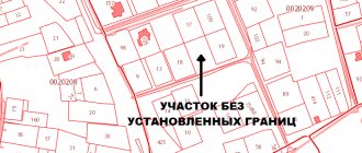
Clarification of the boundaries of a land plot is carried out in relation to land plots for which the exact boundaries are not defined (the coordinates of the characteristic points of the boundaries are not established).
You can clarify the boundaries of a land plot on your own initiative or when performing complex cadastral work. As part of this procedure, the specified boundaries must be agreed upon. New information about the boundaries of the land plot is entered into the Unified State Register of Real Estate. This must be done in the case when a land plot that is publicly owned is provided without bidding. It will not be provided to you if the boundaries of such a site are subject to clarification. There are no other mandatory cases when it is necessary to clarify the boundaries of a land plot. It should be taken into account that previously plots were placed on cadastral registration without determining their exact boundaries. Therefore, a large number of areas in the Unified State Register of Real Estate do not have exact boundaries. If the coordinates of characteristic boundary points have not been established for a land plot, it is recommended to carry out a procedure for clarifying them. As a result, the exact boundaries of the land plot will be determined. First of all, this will protect the owner from appropriation of part of the plot and disputes with the owners of adjacent plots about the location of the boundaries. Clarification of the location of the boundaries of a land plot is allowed in cases where the Unified State Register of Real Estate: - does not contain information about the coordinates of characteristic points of the boundaries; — the coordinates of characteristic points of the boundaries are determined with an accuracy lower than the standard accuracy for lands of a certain purpose; — information about the coordinates of any characteristic point of the borders does not allow one to unambiguously determine its position on the ground; — there is an error, including a registry error, about the location of the borders and measures are being taken to correct it. Currently, the boundaries of a land plot can be clarified both at the initiative of the owner and during the performance of complex cadastral work. To clarify the boundaries of a land plot, you must contact a cadastral engineer and conclude an agreement to perform cadastral work. As a result of cadastral work, a boundary map is drawn up, which will determine the exact boundaries of your land plot. When clarifying the boundaries of a plot, the boundary plan must include information on the approval of the boundaries of the land plot. Complex cadastral work is carried out in relation to most real estate objects located within the boundaries of one or several adjacent cadastral blocks. This is necessary in order to clarify the boundaries of land plots, establish (clarify) the location of buildings and structures on them, form new land plots, as well as to correct registry errors in information about the boundaries of land plots. To clarify the boundaries of a land plot, information from documents on the right to land plot. If they are not there, you can use documents on the boundaries of the site when it was formed. If there are no such documents, the boundaries of the land plot are considered to be those that have existed in the area for 15 years or more and are fixed by natural or artificial objects. Boundaries can also be determined using other documents, for example, planning and cartographic materials available in local governments of urban districts. Based on the results of comprehensive cadastral work, a map-plan of the territory is prepared. It includes information on the approval of land boundaries. When clarifying the boundaries of land plots, their approval is carried out. The approval procedure differs depending on how the boundaries of the site are specified - on your initiative or during complex cadastral work. The boundaries of adjacent land plots must be agreed if their clarification was carried out at the initiative of the owner. This is also done in the case when the boundaries of adjacent land plots, information about which is included in the Unified State Register, are clarified. The boundaries of the plot are agreed upon with the following persons who own adjacent land plots: - owners, except in cases where the plot is in public ownership and is provided with the right of lifelong inheritable possession or the right of permanent perpetual use; - persons to whom the plot belongs by the right of lifelong inheritable ownership or permanent (indefinite) use; - tenants, if the site is publicly owned and leased for a period of more than five years. Coordination can also be carried out with representatives of these persons. Coordination of the boundaries of a land plot can be carried out: - with or without establishing boundaries on the ground; - by meeting or individually with each person. If a meeting is held, then all interested parties (their representatives) are given a notice of the meeting against receipt (sent by mail or e-mail to the address contained in the Unified State Register of Real Estate). In some cases, it may be published in official media. Notice must be served, posted, or published at least 30 days before the meeting. As a result of the approval of the boundaries of the land plot, an approval act is drawn up on the back of the sheet of the graphic part of the boundary plan. Entering updated information about the boundaries of a land plot into the Unified State Register of Real Estate is carried out by applying to Rosreestr for cadastral registration of changes in the description of the location of the boundaries of the land plot and (or) its area.
Why is it necessary to clarify boundaries?
Currently, this process is not considered mandatory. It is important to take into account that situations may arise when without carrying out the boundary process it will not work. In this case, it does not matter whether the owner has a desire to bear the costs associated with land surveying. This happens if there is no documentation confirming the rights of ownership, and the rights are registered only for the building located on the site. To be able to carry out privatization, you will need to clarify the allotment lines. The administration of each municipality has the right to transfer land into ownership on a paid or gratuitous basis. This is influenced by what documents are issued for the land.
Regardless of the fact that clarification is not considered an obligatory stage, citizens often refuse to acquire land if its boundaries are not established. For this reason, land surveying gives a better chance of selling a plot. If there are no lines drawn in accordance with current legal acts, then it will not be possible to obtain a permit for construction work. In addition, this allows a citizen to avoid controversial situations, litigation, and loss of space. It is worth considering that the boundaries of plots located in an adjacent order are sometimes established with errors. Then there is a superposition of one allotment on another. This overlap can be complete or partial.
IMPORTANT !!! When taking into account boundaries in Rosreestr, intersection of plot lines is not allowed. Despite the fact that difficulties have arisen in the adjacent lands, it is the owner who initiated the process of clarifying the boundaries who will not be able to complete it. To prevent such situations, it is necessary to correct the error regarding the location in which the land is located.
If citizens who own plots do not show a desire to carry out a repeat land surveying procedure, they will need to contact the judicial system. If the other party does not recognize the stated requirements, the judge will order a study. The cost of this procedure will be much more expensive than the preparation of boundary documentation. Costs will be borne by the party whose boundaries are inaccurate.
What does the lack of clarification of boundaries lead to?
The volume of land not properly recorded is a national problem, as it leads to their misuse. For the owners themselves, the fact of the absence of a cadastral number, registration and certain boundaries is a big obstacle when making property transactions, as well as when registering ownership of a land plot.
Sales of plots that do not have technical passports and are carried out at a reduced cost. In addition, the lack of clearly defined boundaries may lead to the alienation of part of the land. Thus, surveying and clarifying the boundaries of land plots is an important and mandatory procedure for rights holders.
Boundary clarification activities
On average, no more than a month is allocated to carry out the land surveying process. However, this may take longer when a controversial situation arises between persons who have plots in the neighborhood or the issues are expected to be resolved in court. A citizen must understand what the procedure for implementing the boundary procedure looks like. Initially, an appeal is made to a cadastral engineer. This is necessary to order documentation. The specified specialist goes to the area and takes the necessary measurements. Then the owner of the territory is given an act for approval. It will be necessary to collect signatures from neighbors. This indicates that they are not opposed to the procedure in question.
ATTENTION !!! It is worth noting that coordination is carried out only with those persons whose plots are located adjacent. If they have clarified the boundaries, then coordination with them will not be required.
When the specified document is completed, the authorized person generates and issues this act in electronic form. In addition, the customer will receive a paper version of the documentation. The owner must contact the branch of the registration authority or a multifunctional center. This is required to submit your application. It reflects a request to change the information contained in the registers. An employee of the listed organizations is involved in preparing the application. A citizen does not have an obligation to pay state duty. You will need to take with you a document that verifies the identity of the citizen.
Documentation regarding the site is also provided. You will need a disk containing the boundary plan. Documentation is produced within the established time frame. The law allows for this from 10 to 12 days. After this time, the citizen will be able to pick up the extract made from the register. At this stage, the land surveying process can be considered completed. The land owner will be able to verify the information by accessing the public map. It is posted on the official portal of the registration authority.
Clarifying the boundaries of a land plot: the right approach to resolving the issue
When purchasing a plot of land, one cannot help but pay attention to the issue of determining its boundaries.
If the previous owner did not take care to carry out the necessary procedures to clarify the limits of the land allotment, the current owner has no choice but to seriously address this issue.
If you do not clarify the boundaries of the site in time, then, most likely, in the future this will lead to conflicts with neighbors, which may result in lengthy litigation.
To avoid this, this article will describe in detail when and how to clarify the boundaries of a plot of land.
Legislation
The bulk of issues relating to the procedure for clarifying the boundaries of a site are regulated by Federal Laws No. 218 “On State Registration of Real Estate” and No. 221 “On Cadastral Activities”.
The latter contains official information about clarifying boundaries and carrying out cadastral work in the complex.
The document obtained as a result of this work will be the basis for entering new boundaries into the State Property Committee by the authorized body (Rosreestr).
In other words, clarification is necessary when the cadastral register does not contain information about the specific location of the land plot in the cadastral register.
However, such a plot has an assigned cadastral number, passport and plan, that is, it is registered and registered.
Hence, with a high degree of probability, difficulties may arise when making any transactions or legal actions with a plot of land in the future, be it a sale, transfer as an inheritance, or during the construction of some objects on the land.
- If, when purchasing a plot, the future owner saw that the documents contain information about the location of the plot, it is better, after the transfer of ownership, to immediately clarify its boundaries by contacting the authorized government agency (Rosreestr).
- When controversial situations arise with neighbors and the question arises about who owns what amount of land.
- When a lawsuit is filed with a requirement to clarify the boundaries, if the plaintiff has suspicions that part of his land plot was illegally appropriated by the owner of a neighboring plot. Based on the filed claim, a court case is opened and, based on the results of its consideration, a court decision is made with a requirement to clarify the boundaries of adjacent land plots. This settles the dispute.
- When carrying out land management work.
- In case of a cadastral error in the documents for the site, as well as errors of the cadastral engineer who carried out the clarification. If this happens, the previously carried out survey is declared invalid, which entails its re-conduct.
At a minimum, the following documents must be prepared:
- cadastral extract;
- cadastral passport;
- certificate of ownership or other document certifying the right of an interested person to the site;
- address order.
It is worth immediately noting that the packages of documents for submission are different in each specific case. It all depends on what right the plot belongs to a citizen or organization, what type of permitted use, and location features. It also happens that some land documents have to be ordered from the archive, which means spending additional time on this, etc.
They will be able to carry out the entire range of work and will issue a ready-made document to confirm this.
Do not think that clarifying boundaries is a very complex and confusing process.
If you follow a step-by-step action plan, this will be quite easy to do, but you will have to spend some time and money.
But, despite this, after clarification, the user of the land can safely carry out any actions with it, without fear of problems with neighbors, possible litigation, etc.
Clarification of boundaries falls within the competence of the cadastral engineer.
In order to attract such a specialist to work, it is necessary to use the services of a geodetic company.
The general algorithm of actions is as follows:
- You need to prepare a package of the above documents for the site and decide on the task that will be the task for the cadastral engineer. Contact the selected surveying company and conclude an agreement with it for the provision of cadastral services.
- Before the cadastral engineer arrives, it is necessary to notify all neighbors about what time the work will be carried out, if the reason for clarification was a difference of opinion regarding the boundaries of adjacent plots. It is recommended to notify neighbors no later than 7 days before the start of boundary work.
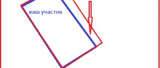
- On the appointed day, cadastral engineers go to the site and measure the actual boundaries of the land plot, and also mark them with a dotted line on the plan. During the measurements, specialists will ask all users of adjacent areas present whether they agree with the resulting boundaries. This is where the field work ends.
- Next, based on the results obtained, cadastral engineers begin to formulate a boundary plan and draw up an approval act. Such an act is signed only by the owners of those adjacent lands that are not registered in the cadastral register.
- The act of approval is signed by the following persons: the owner or representative by proxy; neighbors of adjacent unregistered land plots; cadastral engineer who carried out the work; a representative of the local government who certifies the boundaries of municipal or state lands.
- When the act is ready, it is attached to the boundary plan and transferred to the customer in paper form, signed by the cadastral engineer and affixed with the seal of the organization. An electronic copy of the boundary plan, signed using the electronic digital signature of the cadastral engineer, is transferred by him to the Rosreestr body, or the customer himself transfers there paper and electronic versions of these documents.
- Submitted documents are checked by Rosreestr specialists and, based on the results of the review, a decision is made either to approve them or to refuse to clarify the boundaries. If a positive decision is made, then a corresponding act is issued confirming that the updated boundaries will be entered into the State Property Committee and a cadastral extract for the site. Or a decision to refuse is issued. In the latter case, you need to contact the geodetic company again to correct the errors and resubmit the documents to the cadastral chamber.
The period for cadastral engineers to carry out the entire range of work ranges from 15 days to 3 months, and the cost of the services they provide varies from 3,000 to 6,000 rubles, depending on the area and area of the site.
Until 2011, the boundaries of land plots were determined very conditionally, by a descriptive method, but with the advent of new rules, the boundaries of all lands began to correspond to the geodetic coordinate system.
Therefore, the problem arose of superimposing the boundaries of neighboring land plots on each other. To resolve the issue of such a cadastral error (if there is a dispute between neighbors), you need to go to court with a claim to correct it. Based on the results of the consideration of the case, the court will oblige Rosreestr to correct this error, and the newly specified boundaries will be correct.
Or, if local authorities have set a minimum land size limit, then the final boundaries may be increased to this limit. In addition, no government permission is required for this extension and it can be done free of charge.
When clarifying boundaries, it is important to remember that:
- clarification is carried out in relation to plots already registered in the cadastral register;
- for clarification, a land surveying procedure is required, carried out by a specialized company or a cadastral engineer on a paid basis;
- there is a chance to increase the area of the plot free of charge by clarifying the boundaries by 10% in the absence of objections from neighbors.
Dear readers, the information in the article may be out of date, please take advantage of a free consultation by calling: Moscow, St. Petersburg or using the feedback form below.
The amount you will have to pay may vary significantly by region. However, the average cost of resolving the issue of land management ranges from 3,000 to 6,000 rubles. Prices depend on 2 points:
- area of the plot (the larger it is, the more expensive it is);
- from the region where the shooting took place.
As a rule, calculations are carried out by hundredths. For example, in the region the price for 1 hundred square meters is 500 rubles. If the plot is 6 acres, then you will have to pay 3,000 rubles. Payment is due before work begins. Details can be obtained from the cadastral chamber. You can take part in any government program related to land management issues, which will significantly reduce costs.
It will also affect the final cost and whether the site is registered. If not, then additional land development work will have to be carried out. Registration will require additional costs.
How to agree on boundaries?
This stage is an important part of cadastral work. This refers to the procedure for clarifying the lines of a single land plot. It is worth understanding that situations may arise when it is not possible to contact the owner of the site. For example, this happens when a person lives outside the country. It is then envisaged that the initiator will need to send notices to everyone who is interested in carrying out the specified procedure. It reflects the meeting of owners of adjacent territories.
ATTENTION !!! Sending is carried out using postal services. The citizen will need to use return receipts to confirm that it was sent.
If the letter remains unclaimed, the item will be returned to the citizen with a note indicating that the letter cannot be delivered. This happens when more than a month has passed since the document was sent. The returned notice will need to be attached to the survey documentation. Then the boundaries of the territories will be considered as agreed upon. These rules are reflected in legal acts. The situation is different when a citizen refuses to sign the completed act. He must be required to object in writing. They are attached to the application for land surveying. The issue is being considered in court.