What does a boundary plan look like?
The boundary plan consists of 2 parts: text and graphic. Each part is designed completely differently. The text and graphic parts are divided into sections that must be included in the boundary plan. The list of included sections depends on the type of cadastral work being carried out. In this case, the boundary plan must have a title page and content.
The grafical part
The graphic part should also include descriptions of approaches to the land plots being formed, that is, travel routes to the land, passages to the land plot from land plots related to public lands. Access routes to a land plot must be reflected in the boundary plan, even when such routes are established using the easement method (limited right of use).
The graphic part will contain the following sections:
- geodetic construction plan;
- land location plan;
- diagram of land plots and their parts;
- outlines of nodal points of land boundaries.
Text part
The text part of the boundary plan of a land plot contains information entered into the real estate register about this land. The quantity and volume of information entered is established by regulations issued by cadastral regulation bodies at local levels. In the manner and in cases provided for by the legislation of the Russian Federation, the boundary plan must contain an act of approval of the location of the boundaries of the land plot.
The text part includes the following sections in their exact form in accordance with the legislation of the Russian Federation:
- initial data;
- information about measurements and calculations performed;
- information about the land plots being formed and their parts;
- information about changed land plots and their parts;
- information about land plots through which access to newly formed or changed land plots is provided;
- information about the specified land plots and their parts;
- information about the formed parts of the land plot;
- conclusion of a cadastral engineer;
- act of agreeing on the location of the border of a land plot.
Land surveying is paid directly by the person who ordered such a service. The price of drawing up a boundary plan for a land plot can vary significantly depending on the size of the plot, its legal form, the volume of information entered into the land cadastre, as well as the presence of additional work carried out by cadastral engineers.
Cadastral plan: take care of your rights to a plot of land
- General information about the land plot registered in the cadastral quarter;
- A sheet with a completed drawing of the land plot;
- Schematic representation of the location of buildings and structures located on this land;
- Description of the exact location of the boundaries with other areas;
- General data with a detailed description of the location of the boundaries of constructed real estate objects intended for land management with other objects of cadastral division;
- Information about each point of the reference boundary network.
The third form consists of text informing about the characteristic features of parts of the site and various encumbrances. The following two forms, presented in diagrams or drawings, reflect in graphical and text form the boundaries of the land plot and the parts of which it consists.
Procedure

you need to go to the local branch of the MFC.
A specialist consultant will tell you which coupon you need to take for land surveying.
Then you need to wait until your number lights up on the board and go to the indicated window.
An MFC employee will accept documents for processing.
After which the customer will be asked to select a cadastral engineer from the list provided by the MFC.
An agreement must be concluded with the organization represented by this specialist. The center assumes all mediation work and risks.
The MFC specialist will tell you what time you need to come next time. In this case, the applicant is given a receipt indicating which documents were submitted and the registration number, by which you can find out about the status of the application. The applicant must provide his telephone number where he can be contacted.
Defining boundaries
- To determine the exact location of the boundaries, the coordinates of their characteristic points are determined - the places where the earth is divided into parts and where the angles change.
- The location of boundaries is determined in accordance with the procedure determined by the authorities regulating the sphere of cadastral relations.
- In accordance with existing standards, the area of a plot of land is considered to be the area of a geometric figure, which is formed by projections of the boundaries of the plot on a horizontal plane.
- To clarify the boundaries of a site during land surveying, information is used that is in the title documents or in the documents in accordance with which the boundaries were determined when the site was formed.
- If the specified documentation is missing, the boundaries are recognized as those that have existed in the area for more than fifteen years and are fixed by natural objects or objects of artificial origin that make it possible to accurately determine the location of the boundaries.
How to check the quality of services performed by a survey specialist
In other words, how can you make sure that this or that engineer needs to be hired to work with a certain area, so as not to encounter the errors that were written about earlier?

- First of all, you need to make sure that the cadastral specialist is qualified. Qualification will be indicated by the presence of a certificate from a specialist.
- Before concluding a contract, you need to obtain information about a geodesy specialist; this can be done on the Rosreestr website.
- It must be remembered that the activities of engineers in this area are strictly controlled by the relevant government agencies to which they are responsible. They also certify a specialist and test him in a qualification exam.
The most complete information about surveyors is recorded in state registers.
If such a specialist contributes to the introduction of deliberately false information into the text of the documentation, then at best he will face a fine of 5,000 rubles and disqualification for a period of 3 years. All actions of the engineer within the framework of the contract for carrying out all stages of the work can be challenged in the manner prescribed by the legal system.
Let the owners of the plots decide for themselves whether they need land surveying or not. But still, the answer here will be unambiguous and definitely not negative. “The law is harsh, but it is the law,” so the owners are forced to obey its demands, contrary to their previous ideas.
Required documents
Where can I get a land survey plan? To draw up this document, you can contact organizations that provide similar services. They will give you a ready-made boundary plan. If you plan to organize the work yourself, you will take the finished document upon completion of the procedure from the cadastral registration authorities.
What papers are needed:
- application requesting work to be performed;
- a copy of the applicant’s identity card or a copy of the power of attorney of his representative, certified by local authorities;
- a document of title that is the basis for ownership of land: a gift agreement, a purchase and sale agreement, a certificate of inheritance by law/will, and others;
- certificate of state registration of rights;
- original documents from the BTI for buildings located on the site;
- certificate confirming the absence or presence of connected communications;
- cadastral extract;
- extract from the Unified State Register for preparing a description.
Upon completion of all necessary work and activities, you will receive a boundary plan, which must be signed by the cadastral engineer who was involved in the preparation and production of the document. Be sure to check the presence of all the necessary information about the land plot: area, exact boundaries, etc.
In light of the new changes made to land legislation, starting from 2021, it will not be possible to make any transactions with land if the specific plot is not made for the purpose.
Therefore, all landowners need to carry out this before the appointed time, although previously the law was not obligatory to do this. However, the Russian authorities are thinking about expanding the tax base through land properties and reducing the number of unregistered plots of land.
What document is issued based on the survey results and what actions the owner needs to take with it will be discussed in this article.
After the survey has been carried out, as well as on the basis, the cadastral engineer who was involved in this procedure on a specific land plot issues the applicant a special document - which has a paper form and certified by the personal signature and seal of the geodetic company. If necessary, an electronic version of the plan on virtual media is also issued.
The boundary plan clearly shows the updated boundaries of the land plot that appeared after surveying, which will be:

- reliable evidence in court (if, for example, one of the owners of neighboring plots filed a lawsuit);
- the basis for registering a plot of land for cadastral registration (if the land plot has not previously been taken into account).
Types of surveying
There are dozens of different types of land surveys: hydrographic survey, topographic survey, geological survey, cadastral survey, building site survey and geodetic survey.
How to properly read a survey plan depends on the type of survey you are looking at. Many types of land surveys contain a lot of detail and are very difficult to understand without prior preparation.
For example, the results of land surveying for construction contain a huge amount of detail, such as the position of fences, buildings, roads, horizontal placement, detailed measurements and much more.
Below we will look at reading boundary plans.
Why is the work being carried out?
Determining the boundary lines of the territory belonging to a citizen is carried out not only in order to find out the area of the plot or register it with the cadastral registration authorities. Land surveying significantly expands the possibilities for using the territory and also allows you to protect the rights of the owner.
Similar work is carried out to easily perform the following actions:
- Conclude a lease or sale agreement;
- Bequeath land by inheritance;
- Build legally buildings on the allotment;
- Resolve conflicts with neighbors in case of violation of boundary lines of property in court and during pre-trial settlement of the issue;
- To cut land, combine plots, or split the property into several parts.
If you have an ownership plan drawn up by specialists, you can easily prove that a particular territory belongs to a specific land ownership, and also protect yourself from the claims of unscrupulous neighbors.
Requirements for the design of the section - Drawing of land plots
If during land management work the determination of the coordinates of boundary markers was not carried out, but a description was compiled based on information from a topographic or thematic map (plan), the cadastral basis of the image of the Drawing is displayed in a form combined with the topographic part of the content of the fragment of the cartographic work used. 16. The change number is an official registration entry made when registering land plots for state cadastral registration (or entering updated information about previously registered land plots), and is not filled in when drawing up the Drawing.
21 Dec 2021 marketur 212
Share this post
- Related Posts
- Children's Living Wage in Udmurtia in 2021
- Who is entitled to tax benefits for transport tax in Volgograd
- How to find out at what stage the passport is ready
- Chernobyl payments to full-time university students
Form and composition
The boundary plan consists of two main parts, each of which, in turn, is divided into separate sections. They are worth considering in more detail:
Text part
This includes information that is necessary for inclusion in the real estate cadastre.
This part consists of the following sections:
- title page;
- initial data;
- information on measurements and calculations performed;
- information about land plots or parts thereof that are formed as a result of work;
- information about areas or parts thereof that have been changed;
- information about the areas through which access to the changed or created plots is provided;
- data on real estate objects or parts thereof, which are being specified;
- conclusion of a cadastral engineer;
- the act of agreeing on the location of the boundaries of the allotment.
The grafical part
It includes the following sections:

- scheme of geodetic constructions;
- layout of land plots;
- drawing of plots, as well as their parts;
- outlines of nodal points of allotment boundaries.
It is worth considering that the specific composition of each part of the document depends on what kind of work it is the result of.
In particular, some information is mandatory in all cases, while others are entered only in some of them.
A drawing of the land plot and its parts is
Subject to compliance with the specified standards, the specialist draws red lines at the location of the boundary boundaries. Transferring information from the drawn up plan to the area, he leaves the old boundary marks, installing additional pegs that define the boundary lines of the newly formed lands. Here it is required to draw up an autonomous plan for each of the newly formed areas. There are many programs for designing houses on the software market. 1 2 3 Information about changed land plots Cadastral number of land. Deprecated: preg_replace(): The /e modifier is deprecated, use preg_replace_callback instead in /home/users/7/700701/domains/moetv.org/engine/classes/templates.class. In the scheme of planning organization of a land plot for individual housing. Land plot program 7 plots (routes) for. Paid and free programs for planning dacha land If previously all drawings and diagrams were drawn up manually, in pencil.
Please note => Leasing for individuals without a down payment for a car
Graphic part of the boundary plan
In addition to the text block, the boundary plan includes a graphic part - displaying the obtained information, calculations and measurements on diagrams and drawings. The required sections of the graphic part of the boundary plan Order No. 921 includes a diagram of the location of the object and a drawing of the site or its parts. Additional sections of the graphic block that can be filled in when carrying out certain types of cadastral work include a diagram of geodetic constructions and outlines of nodal points of the object’s boundaries.
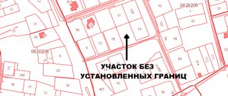
Layout of land plots
The graphic part of the boundary plan is drawn up simultaneously for all plots or parts thereof being formed. When clarifying the boundaries and area, the cadastral engineer graphically displays the boundaries of each area being specified. The layout of the sites is prepared on the basis of USRN information containing cartographic data, or using other cartographic material.
When filling out this section, the location of the site is displayed in graphical form relative to adjacent objects and the boundaries of the cadastral division, and the diagram indicates:
- the boundaries of the object on which cadastral work was carried out, as well as the boundaries of adjacent plots;
- boundaries of municipalities or settlements;
- boundaries of cadastral division;
- boundaries of territorial zones, cultural heritage sites, etc.
If a boundary plan is prepared during the formation and formation of a new object, the diagram will reflect lands or areas of public use.
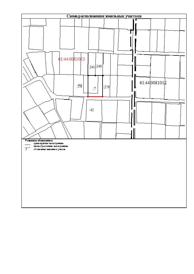
Drawing of land plots and their parts
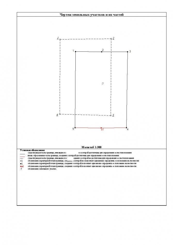
A drawing of the site or its parts is a mandatory element of the boundary plan. The contents of this block include the following data:
- location of existing, new and defunct characteristic border points;
- parts of plot boundaries, as well as parts of objects;
- designations of land plots and characteristic border points.
When transferring the specified information into a drawing, the cadastral engineer is obliged to use a scale that ensures readability of the location of characteristic boundary points. All created or refined sections, as well as their parts, are displayed on the drawing field. The design of the drawing allows the use of callouts or insets on separate sheets, if necessary to display individual boundary points.
If the boundary plan is drawn up to clarify the boundaries of the site, an approval act is drawn up on the back of the drawing. When filling out the specified act, it is mandatory to indicate the passport data of the copyright holders of adjacent objects, or information about their representatives.
Additional sections of the graphic part
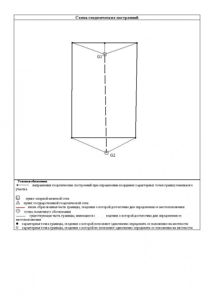
The geodetic construction scheme takes into account the information obtained as a result of site measurements. In particular, this section will include:
- a schematic representation of the object in respect of which cadastral work was carried out;
- location of geodetic base points on the ground;
- location of shooting justification points, etc.
The content of this diagram may differ significantly depending on the methods used to determine coordinates. The most accurate is the method of satellite geodetic measurements, in which the points and base stations of the geodetic basis, as well as the distance from the base stations to the nearest characteristic point of the border, are reflected on the diagram.
Order No. 921 regulates the condition under which the boundary plan includes the section “Outlines of nodal points of the boundaries of land plots” - if the nodal point is located within a radius of up to 40 meters from three or more long-term and clearly identifiable objects (for example, elements of capital construction projects - buildings, structures, etc.). A nodal point is a characteristic point common to the boundaries of three or more land plots. When displaying an outline, the distance to identifiable terrain objects is indicated.
Geodetic plan of the land plot and its features
- A large scale is used, which does not allow depicting small objects in detail;
- Degree grid lines are displayed, taking into account, among other things, the curvature of the earth's surface;
- A special system of symbols is established, which differs from that used when drawing the area plan. First of all, this concerns color schemes: on a map, colors are used to display altitude, and on a plan, to indicate individual relief objects, such as mountains or forests.
- Relief , usually presented in the form of basic and thickened contours. The height of the area is indicated by colors, and the highest and lowest areas, including the depth of hydrological objects, are indicated by dots indicating the number of meters above sea level.
- Water objects . In addition to the direct image available at the site of a stream, lake or other hydrological resource, its name, as well as the direction of flow, is applied to the plan. Its speed is also indicated using symbols.
- Network engineering:
- Power lines;
- Gas pipes;
- Communication lines;
- Other communication facilities located both above and below the ground.
- Boundary lines , for specific land plots - extreme and turning points.
- Road communications.
- Vegetation and soil type . It is specified using conventional signs.
- Fences – any types of fences and fences.
- Buildings , indicating the number of floors and whether they belong to residential or non-residential premises.
Please note => Conditionally early for 228 who left