Good day everyone! It's time to figure out the topographic plan. What is it and what do you eat it with and what do you eat it with? We will explain in clear language what a topographic plan of a land plot is and why it needs to be done.
Previous article: “I bought a plot. What's next?"
What is a topographic plan
And in general, you really need to contact the geodetic service or private owners (with a license). In order for you to be “drawn” a primitive plan of your own piece of Russian land?
Topographical plan of a land plot - what is this?
Yes - without a topographical plan of the site, no one will allow you to build, let alone, your dream house. But you can’t see a hut on chicken legs either.
Science defines the concept of “topography” as a branch of geodesy that deals with measuring mother Earth and depicting it on maps. Since we are interested in the topographic plan of the land plot, obviously the measurements will not concern the entire blue planet. But only that piece of it, which is your sole and indivisible property.
Moreover, in fact, the topographic plan of the land plot is not even a “primitive” diagram. A drawing set of horizontal lines, designations of all elements and objects, as well as relief marks located on your territory.
By the way, developers often do not know how the topographic plan of a land plot differs from the situational one. In principle, the difference between them is only in scale: the situational one is carried out on a scale of M 1: 2,000, 1: 1,000 and is used to create a communication plan and technical conditions.
For any plan, it is important to choose the right scale. When they make a topographical plan, and as we have already found out, surveyors do this. To develop a construction plan, a “five hundred” is usually used. So in professional slang, level and theodolite workers (without them a surveyor is like an astronaut without a spacesuit) call the scale 1: 500 (i.e. 1 cm on paper corresponds to 5 m on the ground).
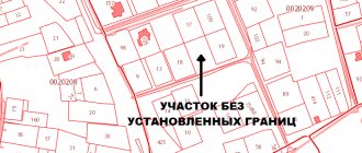
The topographic plan of the land plot looks like this:
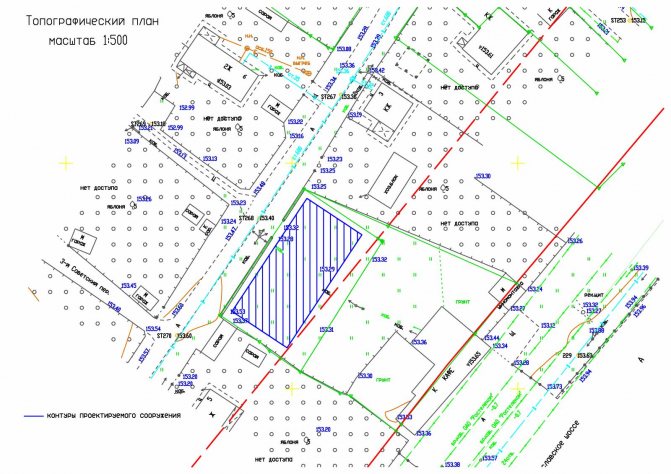
This is what he looks like
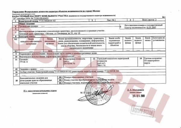
Cadastral passport
A passport is required to register land. Without it, you won’t be able to sell, buy or donate real estate. It is issued only after the allotment is registered. This process involves assigning a number to the land.
It should be noted that the passport is valid as long as the data recorded in it is true. If any changes occur, you will need to enter data and draw up a new land plot plan.
Shooting without film and photo
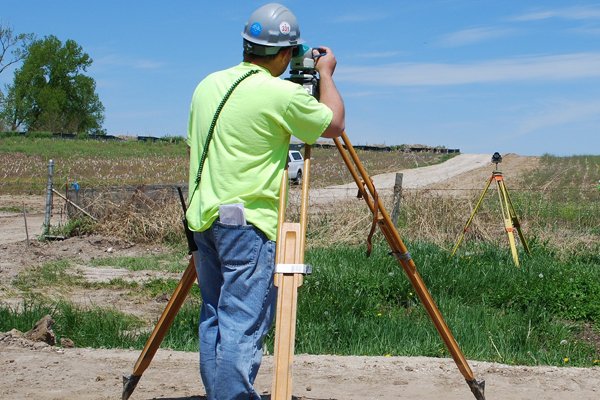
Obviously, in order to obtain data from which it will be possible to draw a plan of your territory, you first need to make certain measurements, for example:
- heights;
- distances;
- corners, etc.
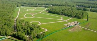
If you become the owner of not just a measly few hundred square meters, but a nth part of the region (yes, some people are lucky!), in this case, the surveyor will not go “out into the field” on his own two feet, but at a minimum, fly in a light airplane while performing aerial photography. Or uses a drone with special built-in geodetic equipment.
But if this is not your case, then everything will be simpler and cheaper. Therefore, before starting “field” work, this is what is called on-site measurements. Surveyors make a alignment base - an aid to this very topographic survey.
And this “help” consists of a construction grid, transverse and longitudinal axes, showing the positions of buildings and their dimensions. The construction grid divides the paper on which the plan will be made into rectangles and squares with a side of 100-200 m (main grid) and 20-40 m (additional).
! Topographic survey is carried out using an electronic total station and a navigation receiver, which identifies the boundary coordinates of points. !
In order for the topographic plan of a land plot to appear on paper, it is necessary not only to survey “in the fields,” but also to perform office work. They have the same relationship to chamber music as a lion cub has to Google: by this term, geodesic engineers understand the execution of calculated data that is obtained using computer and special graphic programs.
Sample and form of KPZU
The cadastral plan forms were approved by Article 14, Part 7 of the Fed. Law No. 221 “On the State Real Estate Cadastre” dated July 24, 2007. The KPZU is issued to the customer in quantities of 2 copies on sheets of A 4 format.
Forms (application) You can.
Sample cadastral plan for a land plot (clicking on the picture will open it in a new window in full size):
When is a topographical plan of a plot of land needed?
So, so as not to make a fuss in vain, not to order too much and not to find yourself without what you need, remember: there are only 5 cases when a topographic plan will become a vital piece of paper:
- To obtain permission to construct a capital facility. No, of course, you can build a “self-construction” on your own site, having all the permissions for development in mind. But know: when the time comes to sell, donate, or otherwise legally deal with your own farmstead, you or your heirs will be in for another unpleasant surprise... So it’s better to still make a topographical plan - it’s calmer that way.
- Don't build anything yet, let it be. But to begin with, to make a project for the future “family farmstead” with buildings, also without a topographic plan of the site, neither here nor there.
- If everything has already been built and built on your own land, and you have an urge to connect to centralized sewer, water or gas lines, you can rest assured that without a topographic plan there is no point in going to the specialized operating organizations. By the way, if you decide to redesign underground communications, also make such a plan.
- Do you dream of legitimizing “extra” acres under the “dacha amnesty”? Why dream - make a topographic plan, and go ahead - with blessings and prayers!
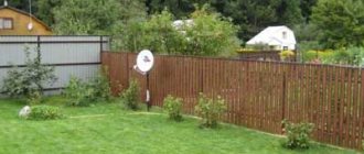
- When the house is standing, the bathhouse is heating, and tomatoes are ripening in the greenhouse, it’s time to think about landscape design. This is why they order a landscape topographic survey, which is used to make a topographic plan of the same name. True, it is more detailed, in M 1: 100 or 1: 200 (so that every bush and tree would be clearly visible).
In general, remember a simple truth - without a topographic plan, you will not see the cadastral plan, like your own blades.
Collection of necessary documents
First you need to collect all the papers. If the site is not included in the register, you must first register it. This will require the following documents:
- application from the land owner;
- the owner’s passport or power of attorney if his interests are represented by another person;
- application for registration;
- papers that confirm land ownership;
- land boundary plan;
- a document indicating that the boundaries have been agreed upon with other landowners;
- a certificate indicating the category of land.
If the land has several owners, it is necessary to have papers on the right to a share. The boundary plan should be ordered from third-party companies that engage in similar operations. If the land has already been registered, all you need is an application, a receipt for payment of the state duty and the owner’s passport. In addition, one should not forget about the cadastral number and papers confirming land ownership.
Before completing the paperwork, you should take into account that the cadastral plan of the site is drawn up by land managers for a fee. Usually it is about 10,000 rubles.
Where can you order a topographic plan of a land plot?
Today there are a lot of private geodetic organizations and individual geodetic engineers who are ready to perform topographic surveys and office work and create a topographic plan of a land plot as the final result of the labors of their righteous people. But do not forget to ask both of them for a license for such types of work.
And in order for an organization or individual to start work, they must provide them with the following documents:
Topographic plan of the land plot
- technical task; (looks like this) (usually filled out by you or the geo-company on their form);
- title (or title) documents for the land and objects of all co-owners;
- if available, BTI technical passport (if there are buildings);
- photocopy of passport (or copy of constituent documents);
- a copy of the power of attorney (if it is not the owner of the site who orders).
Where to get it
Art. 8 of the Civil Code of the Russian Federation gives local government authorities the authority to prepare and approve settlement plans, the right to issue permits for the development of territories and approve land use rules. The owner of the site can order a situation plan:
- in the municipality;
- in a private company specializing in the preparation of graphic and descriptive documentation of real estate.
The provision of services by the administration of the locality is carried out on an application basis free of charge. A commercial organization sets its tariffs in accordance with the volume of work performed.
When contacting a municipal authority you will need:
- completed application;
- passport of the owner of the territory;
- documentary evidence of ownership of the land plot.
The following grounds for refusal to provide services are assumed:
- an incorrectly drawn up application;
- the person applying for the provision of municipal services is not the owner of the land;
- the applicant has not provided all the necessary documents.
In other cases, you can appeal the municipality’s refusal in court.
You can order the production of a situation plan using the cadastral number of the site. Most of the real estate objects are assigned a specific number, which allows you to identify a specific land and find out its main characteristics.
Regardless of the method of obtaining the plot - inheritance, donation, purchase and sale - the cadastral number is retained. In this case, the citizen can apply:
- upon application to Rosreestr;
- upon personal visit to the MFC.
The list of documents provided is similar to what is submitted to the administration of the locality. It is important to pay attention that if there are residential properties or outbuildings on the site, title documents for them are also submitted.
A situation plan is prepared within 10 days after contacting Rosreestr or the MFC. The service is provided free of charge to both citizens - land owners and representatives of a legal entity acting under a notarized power of attorney. The refusal must be made in writing.
For gasification
You can obtain information about where to draw up a situation plan for a specific site from the gas supply organization at the location of the land. At the first stage, you will need coordinate data for the territory. If there is no such information about the site:
- the owner of the land can contact an architectural company that has a license to draw up site plans; a specialist will take measurements of the territory and draw up a plan on a scale of 1:2000;
- make a diagram of the land plot and a description for it yourself, using satellite images.
If the owner of the land intends to gasify the facility, a situation plan will be required for connection to the gas pipeline by engineers of a specialized office. The document is submitted in A4 format with an image of the site in the context of reference to the area in which it is located. The professional activities of a cadastral engineer are regulated by the provisions of Federal Laws No. 221-FZ and No. 128-FZ.
For electrical networks
The owner can obtain a situational plan of the land from the municipality. In special cases, it is necessary to obtain approval for the installation of electrical networks. The territorial committee of architecture may be involved in resolving the issue.
Electrical networks require a situational plan on a scale of 1:2000 or 1:500. It will have to be compiled after photographing the area. It is necessary to draw diagrams of energy-receiving capacities. The document must display the following information:
- land boundaries;
- erected buildings;
- power lines;
- places of connection to the electrical network;
- voltage power;
- types of electrical equipment;
- designation of the cable for supplying current, its characteristics.
The work must be certified by the contractor, who took measurements and displayed the objects graphically. You will also have to seek assurance from the head of the territorial cadastral service.
General provisions
Cadastral registration refers to certain sequential actions carried out by a state organization authorized to enter data about a real estate property into the general register. This information is a guarantee that the property actually exists.
Based on the completed registration, Rosreestr issues the owner documentation, which includes a plan of the land plot. Previously, such a document was called a cadastral passport.
From January 1, 2021, Rosreestr does not issue cadastral passports. Instead, owners receive extracts about the real estate from a unified register. Therefore, the State Real Estate Cadastre (GKN) was abolished. All information from it was transferred to the EGRN (Unified State Register of Real Estate).
The main action in cadastral registration is the creation of a plan for the property. It is a diagram indicating the boundaries of a specific plot, which is compiled according to the cartographic principle. The plan contains graphical and textual data using information requested from the State Land Cadastre (GKZ).
Passport production time
According to federal law, the issuance of cadastral information about land must occur within 5 days. This period is counted from the day the application is submitted. It should be noted that the papers received by the land owner have an unlimited shelf life.
It is necessary to change the issued passport in some cases:
- when the owner's full name changes;
- change of place of residence;
- change of address;
- expanding boundaries.
In addition, an inventory of real estate assets takes place every 5 years. After this procedure, you receive a new passport. But it should be noted that if there have been no significant changes at the site, obtaining a new document is not necessary.
When can extradition be refused?
The issuance of this document can be refused only in one case - if there is no data about it in Rossreest, that is, the land plot has not been registered. But issuance can be suspended in several situations, namely:
- there is a discrepancy between the cadastral number and the property document;
- discrepancies in the data on the size of the plot in the property document with the data in the Rossreestr;
- a new survey was carried out, but changes were not made to the Unified State Register, etc.
The suspension is carried out for a period of one to three months, with notification of the owner. It indicates the reason for the suspension and the period for elimination. After this period, a new request must be submitted.
The most popular and less time-consuming method, as mentioned above, is a request via an electronic application to the Rossreestr office. All you need is the appropriate equipment and Internet access.
Receipt procedure

First you need to carry out land surveying and draw up a land survey plan.
After collecting all the necessary documentation, you can contact the relevant authorities to obtain a cadastral plan.
You can receive it in person or order it online.
You should contact Rosreestr or the MFC (Multifunctional Center), or the Unified State Register of Lands.
To receive a document in person, you should follow the following steps sequentially:
- At Rosreestr or at the MFC at your place of residence, take an application form and carefully fill out all the necessary points. Be sure to consult with an employee of the institution on how to fill out the form correctly. Don't forget to indicate the number of copies of the CP you need.
- Provide the registrar with all the necessary documents that you brought with you.
- After checking that the form has been filled out correctly, the registrar must give you a receipt stating that he has accepted your documents and list their names and number of copies.
- Pay the state fee for each copy.
- In a few days (usually 5-7, but sometimes longer, but not more than a month) the documents will be ready. If everything was completed correctly and government employees do not have any complaints or additional questions against you, then you can safely receive them in your hands by presenting a receipt and a passport of a citizen of the Russian Federation.
To receive online via the Internet, do the following:
- On the official website of Rosreestr, go to the “Individuals” tab.
- Click on the tab “Obtaining USRN information”
- Next, go to the tab “Get cadastral plan of territories from the Unified State Register of Real Estate”
- The USRN information request form will open. We fill in all the required fields. In the “In form” column, select what document format you need: a link to an electronic document, a paper document by mail, or a paper format in the territorial department of Rosreestr. We also indicate the public cadastral number and address of your site.
- Go to information about the applicant by clicking in the lower right corner of the form.
- Here we select whether you are an individual or a legal entity, as well as the category of the applicant (you can indicate “Other person”). Fill in all required fields marked with a red exclamation mark. We enter passport data or data from another identification document of the applicant.
- We submit a verification request form, having previously agreed with the transfer of personal data to Rosreestr. After this, you will receive an email with an approximate production time for the CP.
How to submit an application
After preparing all the necessary documents, they are submitted to Rosreestr. At this stage, the owner of the land is given a receipt. It will be required when you receive your passport.
The state duty is 200 rubles. If the passport is issued by a legal entity, the cost will be 600 rubles. It is worth noting that all papers must be provided at the location of the land.
Registration procedure, required documentation
If there is not enough information to register the plot, Rosnedvizhimost specialists will give you a certificate with a list of documents that do not meet the conditions for inclusion in the State Land Cadastre. They will need to be collected. For this purpose, contact a commercial company with an order to carry out land management work.
After they are completed, you will be given a document describing the plot of land. It will need to be submitted to the regional office of Rosnedvizhimost, accompanied by the following documents:
- a certificate that confirms your ownership of the property;
- application for cadastral registration;
- passport of the owner of the plot.
Cadastral registration takes place without any problems. The exceptions are the following situations:
- the identified excess area of the site during its delimitation exceeds the established minimum;
- the owners of neighboring plots have claims to the existing boundaries of your site.
After registration, you should return to the initial stage, that is, contact Rosnedvizhimost with newly received documentation to draw up a cadastral diagram. The organization’s specialists are required to do it within 30 days.
Sometimes it turns out that the actual area of the plot is more or less than the figure specified in the documentation. Then information about the size of the site from the demarcation certificate is entered into the State Land Reserve.
It is also possible to obtain a site plan compiled by the State Land Cadastre via the Internet. This is done on the official website of Rosreestr. A set fee is charged for this.
The duration of the KPZU is not specified by law. The plan remains legitimate until the information in it loses its relevance due to actual changes on the site. For example, this could be a change in the contours of the plot. Then a new demarcation with all subsequent actions will be necessary.