What documents are needed to divide a land plot?
A complete list of points that do not allow division is set out in Art.
11.9. ZK RF. Among the main ones we can highlight: Conditions When dividing land, the most important goal is the following: 1 plot should turn into 2 independent territories. Legal subtleties. Divisible and indivisible A divisible plot is one that can be divided into parts that will be independent in nature. If there are no buildings located on the land, it will be divided in accordance with its permitted use and minimum size.
Formation of land surveying
Part of the boundary work is the boundary plan - this is a document drawn up on the basis of the cadastral plan and which corresponds to the territory or cadastral extract of the corresponding land plot. The boundary plan must reproduce the information available in the state real estate cadastre, indicate information about the land plot or plots being formed, about part or parts of the land plot, including new information necessary for inclusion in the state real estate cadastre. If, in accordance with No. 221-FZ “On the Real Estate Cadastre in the Russian Federation,” the boundaries of the land plot being demarcated are subject to mandatory approval, then the boundary plan must also contain information about such approval.
- - land plots formed during the division, merger, redistribution of land plots or separation from land plots;
- — land plots formed from lands in state or municipal ownership;
- - land plots, from which new land plots were formed as a result of allocation to account for the share(s) in the right of common ownership;
- — land plots in respect of which cadastral work is being carried out to clarify information from the state real estate cadastre.
We recommend reading: New sample forklift driver's license photo
Necessary documents for land surveying
- An application for the organization to carry out the necessary land management work;
- Original and copy of passport (customer or authorized representative);
- All certificates and certificates confirming the right to own the current plot of land. In the event that you have recently owned the property, an administrative resolution is required to prove your right to own this land plot;
- Copies of documents that inform you about how these lands came into your possession (inheritance, deed of gift or purchase/sale);
- A complete package of documents from the Bureau of Technical Inventory;
- If there are any buildings on the land plot, their cadastral passports will be needed. At the same time, if there are no buildings, certificates about the absence of buildings will be needed;
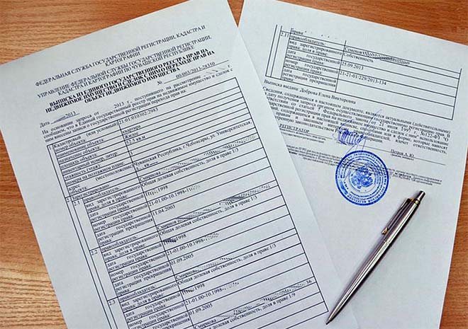
- Extract from the land registry;
- Cadastral plan of the territory.
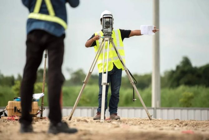
First, you need to understand what land surveying is and why is it needed? In simple words, land surveying is the establishment and coordination of the boundaries of a plot of land, carried out by the company’s geodesy specialists. After completing a set of works, the exact area of the site and its boundaries are fixed.
Stages of land surveying
Let's consider how land surveying occurs. Firstly, in order to avoid further problems and the need to repeat the operation, it is better to entrust the surveying procedure to an experienced specialist who represents a serious organization and guarantees the quality of the work performed, ensuring the preparation of all necessary documentation. Stages of land surveying and preparation of a land plot plan:
1. Inspection of the site and collection of data for drawing up a boundary plan.
2. Collection of the necessary package of documents (ownership rights, registration of buildings, etc.).
3. Establishment of site boundaries based on documentation.
4. Creation of a technical project.
5. Determination of the need for work, their list and deadlines for implementation.
6. Familiarization of the owners of bordering plots with the data obtained as a result of land surveying. Coordination of new boundary data.
7. Installation of markers along the boundaries of the land plot under study.
8. Preparation of a boundary plan for the land plot.
9. Transfer of the boundary plan prepared by the cadastral engineer to the cadastral authority.
10. Registration of the plot in the cadastral register (correction of data in the register when revising erroneously indicated boundaries).
Land demarcation - necessary documents
It follows from this that the delimitation of a land plot means carrying out a complex of legal and survey work to give a certain territory of the earth's surface individual characteristics, assigning a special number, and the ability to use it as an object of civil rights and obligations (purchase, sale, donation and other actions ).
The market for such services includes private companies that set the cost of their work individually, and enterprises whose activities are approved by the state body Rosreestr. The latter have a formula by which the cost of the entire complex of works will be calculated.
What documents are needed to demarcate a land plot?
Boundary plans and, accordingly, land surveying are done by certified cadastral engineers working in geodetic companies or as individual private entrepreneurs. You need to enter into an agreement for the production of a boundary plan and provide the contractor with the necessary documents.
The cadastral plan, which is drawn up by territorial bodies that carry out cadastral registration of land and assign cadastral numbers to land plots, contains all the necessary information about your plot, including its cadastral value, category of land, area, as well as a diagram of its boundaries on a fixed scale indicating coordinates nodal points and the length of each distance between them. If there is no cadastral plan, it is necessary to attach a copy from the general plan according to which the plots were “cut” or a fragment of a topographical diagram at a scale of 1:500 or 1:1000 with the boundaries of the plot marked on it.
We recommend reading: Obligations that are not inherited
Land management (land survey) of a land plot - what is it and where to get it
This process is regulated by the Federal Law of the Russian Federation “On Land Management” (Article No. 22). Having in hand papers that indicate certain boundaries of a plot of land, a citizen becomes its full owner and no one will have the right to cross these boundaries without his consent.
We recommend reading: Vouchers for labor veterans
Since these concepts are directly related to the preparation of papers that are needed to own land and land plots, and are also a mandatory item in all land transactions (construction, purchase and sale, lease). Therefore, it is worth familiarizing yourself with this terminology, understanding the essence, in order to avoid fatal mistakes.
Land demarcation
- a statement written in free form;
- a copy of the applicant’s passport (for citizens) or copies of constituent documents and a certificate confirming the state registration of the company (for organizations);
- papers certifying the right to property or ownership of land;
- a certificate confirming the registration of the original site, a plan of the area where it is located, and an extract from the cadastral list;
- BTI documents for buildings located on the bordered territory.
Delimitation should be understood as the delimitation of a territory into several sections with subsequent registration of their ownership. The procedure is performed for each new object. The Roskomzem instructions describing its implementation say that during land surveying, the exact boundaries of the plot are determined and fixed, its area is calculated and referenced to the terrain is made.
What documents are needed to demarcate a land plot?
Documents for registration are submitted in two ways: in person or by mail with a list of the contents and with a receipt. You will know that the documents have been received thanks to a receipt, which you will also receive by mail. If the application and documents for cadastral registration are submitted by the applicant in person, you will receive a receipt with a list of documents and the date of receipt.
Among the situations in which it may be necessary to make a division, the following can be highlighted: Requirements for the process Those land plots where real estate objects are located, requiring, during division, the removal of a separate part from the property, are not subject to division, in the event that the relationship is strictly defined to a certain part of the dividable land.
Land surveying where to get
Write an application for a copy of the document on the basis of which information about the property is entered into the state real estate cadastre (if for the court, then receive it in paper form). They have a form. Cost: Land survey and technical plan 800 rub. Other documents 200 rubles - for individuals (For legal entities.
hmm, strange, I recently submitted a request to the cadastral chamber of the Moscow region for the provision of land management records, they asked me for a power of attorney from the owner and the original certificate. At the same time, the chamber staff referred to the law on personal data and the regulations of 2006 (I don’t remember the number now).
Demarcation of a land plot: what is it and how much does it cost to delimit a plot into two
- Division of a plot of common property. For example, a similar situation may arise during a divorce, when land needs to be divided between two spouses.
- You want to change the category and purpose of part of the site. In this case, you first need to divide it into parts, and then, in relation to one of the parts, begin the procedure for changing the category and type of permitted use.
- The large plot is in shared ownership, and the owners made a joint decision to divide it so that everyone could fully manage their property. Similar situations occur, for example, when one land is inherited by several heirs.
- The boundaries and area of the original site are established. If land surveying was previously done, the cadastral engineer will use the data available in the register.
- The boundaries of the formed areas are established. They are schematically plotted on the plan of the original site and given conventional numbers.
- Formation of land surveying.
Preparation of documents for the land surveying procedure in 2021
- Formation and consideration of initial information (geodetic, cartographic and title documents).
- Field research and a thorough analysis of the state in which the state geodetic and support boundary network is located.
- Notifying interested parties about the work aimed at delimiting lands.
- Carrying out a survey of topographic (contour) value.
- Calculation of land area.
- Control and acceptance of final indicators.
- Drawing up a boundary plan.
- passport or other document guaranteeing the accuracy of personal information;
- purchase and sale agreement, gift, will and other legal documentation;
- administration resolution confirming the transfer of land rights to a citizen (if any);
- USRN extract;
- a statement notifying that surveying work will be carried out on the site.
We recommend reading: Decision to sell 12 shares of LLC sample 2019 medium-sized transaction no interest
Who should be trusted to carry out land surveying? Required package of documents
The quality of land surveying work depends entirely on the qualifications and experience of the cadastral engineer. To save your own time and money (poor quality surveying will lead to a repeat procedure and the involvement of additional specialists), it is better to immediately contact a company specializing in surveying and providing cadastral services. The qualifications of a specialist are easily determined by contacting the register of cadastral engineers; all information about the work carried out by one or another cadastral specialist, problems encountered during the work, errors made by the engineer is stored here, the information is freely available, and any customer can easily familiarize themselves with it.
Any company that the customer contacts to provide cadastral services will definitely require the following package of documents to conclude an agreement and draw up a boundary plan:
1. Documents on the ownership of the land plot (will, purchase/sale agreement, etc.).
2. Identity card of the customer (for the organization, constituent documents).
3. Documentation of registration with the relevant authority for all buildings (residential premises will require a technical passport).
4. Land plans.

Documents for demarcating a land plot
Certificates of organization registration and tax registration. A document of title on the basis of which the owner has powers in relation to a land plot - a certificate of acceptance of inheritance, a contract of sale, exchange, donation, privatization, an act on the allocation of a plot of land to a citizen or legal entity.
The list of mandatory documents in accordance with Federal Law No. 218 includes (innovation from January 2021), on the basis of which the location of the land and its area are determined. The following documents are required for carrying out land surveying on the basis of the law: Identity card of the applicant - an individual or a representative in case of applying to the authorized bodies of the organization, attaching a power of attorney. Organizations are also required to have a package of documents: a constituent agreement on the formation of the company, a charter with prescribed types of activities, a decision or protocol on the appointment of a person authorized to act on behalf of the company - the head of the enterprise.
Notification of land surveying
The issue of land surveying in Russia is regulated by more than one legislative act; when resolving issues related to the division of land, it is necessary to focus on the following legislative framework:
- Land Code of the Russian Federation.
- Federal Law No. N 221-FZ “On the State Real Estate Cadastre” (directly describes the land surveying procedure).
- Federal Law “On Land Management” dated June 18, 2001 N 78-FZ.
- “Instructions for land surveying” (approved by Roskomzem on 04/08/1996).
What cadastral work includes, more details in this article.
If necessary, the list of regulatory documents may increase. The most discussed law on land surveying today stipulates that land plots that have not been demarcated before 2021 cannot be inherited and cannot be the object of various transactions.
Until this time, the land surveying procedure is not mandatory, but without it it will be impossible to dispose of the land. This means that the owners will still have to delimit their land according to the law.
Before calling surveyors, study the list of documentation required to carry out boundary work, in accordance with the requirements of current legislation. This will help you complete the procedure properly and avoid disputes with the owners of adjacent plots.
The list of required papers may vary depending on who is the customer of geodetic work in relation to land ownership - a citizen or an organization.
The list of documentation that an individual needs to collect to carry out land surveying work regarding the owned plot consists of:
- the applicant's general passport or other identification document;
- legal documents, including:
- purchase and sale agreement (when land ownership was acquired by a person from another owner);
- deed of gift (when receiving land as a gift from the previous owner);
- certificate of right to inheritance (if land ownership was inherited by a citizen);
- an act issued by the administration of a territorial entity on the provision of land to an individual when the object was provided by local authorities;
- certificate of state registration of the right to the plot (if the property is registered in the cadastral register);
- territory survey plan;
- cadastral passport;
- statement on the need to perform cadastral work in relation to land ownership;
- extracts from the Unified State Register of Real Estate.
The above list is fundamental for carrying out land surveying work for citizens.

To carry out land surveying work, an organization should collect a set of documentation, which consists of:
- powers of attorney to carry out necessary actions;
- certificate of registration with the tax authority;
- certificate of state registration of a legal entity;
- documentation prepared by authorized bodies, which proves the fact that the organization is included in the database (individual entrepreneurs or legal entities), in order to avoid fraudulent activities.
Land owners are often interested in the cost and duration of survey work. In general, this takes from ten days to two weeks.
In this case, the owners of adjacent plots should be notified at least a month before the procedure is carried out.
If all the specified rules are observed and there are no comments from the registering authority, the survey case is formalized one and a half months after the submission of the proper documentation.
In addition, remember that if a cadastral passport for the land has not been issued, then within approximately twenty days the object will be subjected to the cadastral registration procedure, after which the specified document will be prepared.
It has already been noted that the survey work is carried out by the relevant company or person holding a license to carry out such activities. You can choose a cadastral engineer yourself. Contact the BTI or talk to friends who have already performed this procedure.
According to the provisions of domestic legislation, the land surveying algorithm includes the following stages:
- submitting an application for the need to carry out the specified work;
- preparation of information on land ownership and review of submitted papers by a specialist;
- registration of the land surveying project;
- notification of owners of adjacent lands about the planned event;
- visit of a cadastral engineer to the area to take measurements and establish land boundaries. In this case, the actual exploited territory is taken into account;
- establishing real estate coordinates. For this purpose, geodetic surveys are carried out using special instruments;
- calculation of land tenure parameters;
- drawing up a plan for the site, according to established information;
- preparation of land surveying.
Upon completion of these activities, the applicant is given a survey document drawn up in two copies, one of which is submitted to the registration authority, and the other is retained by the landowner.
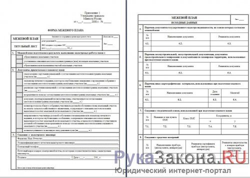
The completion of cadastral work occurs by providing the landowner with a boundary plan. This document includes two parts: text and graphic.
The first records the proper information about the property and consists of:
- title page;
- contents (lists sections of the document);
- initial information about land ownership (location, indication of boundaries, etc.);
- presenting completed measurements and calculations;
- data about the territory being formed;
- information about access to the property and the lands bordering it;
- expert's conclusions.
In the conclusion, the calculations and measurements made, as well as the results established based on them, are justified and explained.
As a rule, preparation of an opinion is necessary in the following circumstances:
- when clarifying land boundaries;
- when establishing discrepancies between actual boundaries and documented ones.
At the same time, in practice, it has developed that the absence of a conclusion may become a reason for refusal of the registration procedure by Rosreestr employees. In view of the above, it is recommended to draw up this paper. Based on the current circumstances, other components may be included in the content of the plan. For example, this may be an act drawn up based on agreement with the owners of adjacent lands.
Its presence is required in the following situations:
- when clarifying the boundaries of land ownership;
- when allocating a new plot from territories owned by the state or municipality.
The graphic component includes schematic images and drawings:
- formed territory;
- established boundaries and access to the property.
These images are recorded using specially designed notations.
The production of a boundary plan is possible both on paper and in electronic form. The first option is drawn up on standard A4 sheets, each of which is stamped and signed by the responsible specialist. The electronic version is signed using a digital signature.
The costs of carrying out this procedure consist of the services of a notary office for certifying the required papers (with the participation of an authorized representative) and the corresponding cadastral work, the cost of which is determined based on the complexity of the activities and the established fee per hour of work.
The complexity of the procedure is determined taking into account the characteristics of the property, its location and other indicators. Thus, the final amount is determined depending on the duration of the work and the characteristics of the particular landholding.
The following documents are required for land surveying on the basis of the law:
- Identity card of the applicant - an individual or a representative in case of applying to the authorized bodies of the organization, attaching a power of attorney. Organizations are also required to have a package of documents: a constituent agreement on the formation of the company, a charter with prescribed types of activities, a decision or protocol on the appointment of a person authorized to act on behalf of the company - the head of the enterprise. Certificates of organization registration and tax registration.
- A document of title on the basis of which the owner has powers in relation to a land plot - a certificate of acceptance of inheritance, a contract of sale, exchange, donation, privatization, an act on the allocation of a plot of land to a citizen or legal entity.
- Confirmation of land ownership - a certificate from the Rosreestr, if the transfer of rights was formalized before 2021, or an extract from the Unified State Register of Real Estate when receiving documents on ownership after January 1, 2017.
- Application form for carrying out boundary work.
- Confirmation of the boundaries of the land plot: cadastral plan or extract from the Unified State Register of Real Estate with the characteristics of the land plot, a certificate from the BTI about the absence or construction of a structure on the plot with a description.
All documents should be obtained in advance, before contacting an organization that has permission for boundary work. This will significantly speed up the process of performing the service.
Quite a lot of people write to us with many of the same questions: how to choose an organization for land surveying? Is it necessary to do land surveying at all and why? Is it possible to buy land if there are no clear boundaries? - for your specific case, it is better to seek advice from an experienced specialist - ask your question.
Papers are provided in originals and copies; it is better to immediately order a certificate from the Cadastre and Cartography Service in 2 or 3 copies for submission to various authorities; duplicates are issued without charging a fee.
The lists of documents for filing an application by individuals and legal entities are slightly different.
To register a plot as an individual you will need:
- An identification document of the owner of the plot (passport) or, if the owner cannot order land surveying on his own, a passport and power of attorney of his representative, as well as copies thereof.
- Legal documents. Among them:
- Agreement for the purchase and sale of land (if it was acquired by purchase from another owner).
- Donation agreement (if the plot was donated to the owner by another person).
- Certificate of inheritance (if the land was received as an inheritance by law).
- Resolution of the administration of the subject of the federation on the provision of a plot of land to the customer (if it was transferred for use by the authorities).
- Certificate of state registration of rights (issued when the owner takes ownership of the property in the Rosreestr authorities).
- Documents that include data on the boundaries, size, geographical location and area of the site: cadastral extract from the register, cadastral plan, certificate from the BTI about the absence of buildings on the site or cadastral passport of the building, if available.
- Application for carrying out boundary work.
What documents are needed to divide a land plot?
If before the decision was made to establish the minimum standard, the land under a private house owned by two homeowners amounted to 7 acres, then the authorities are trying to prevent the privatization of such a site, offering its registration for an indefinite lease.
For each region, both internal and federal legislative acts regulating this point are taken into account; Newly formed ones should not go beyond the boundaries of the locality of their location or another municipal entity; In the case where various objects are located on the sites, the possibility of using them for their direct purposes should be preserved in the same condition; Violation of the rational use of land resources and other requirements contained in federal legislation is not allowed; There are also additional lists that can change in each specific situation, for example, when dividing by two or more.
What to do after land surveying
- Preparation of documents and collection of the package required for submission to Rosreestr;
- Transfer of funds as state duty. At the moment, its value is standard and amounts to 300 rubles ;
- Submission of the prepared documentation package;
- Review by specialists and issuance of a certificate of registration of property rights.
It should be noted that the establishment of boundaries, due to the need for a thorough analysis of documentation, measurement and computational work, as well as approval of the drawn up boundary plan, can be carried out for quite a long time , reaching up to 6 months or more.
What to do after land surveying and what the survey document looks like
Therefore, before the appointed time, all landowners need to carry out this procedure, although previously the law was not obligatory to do this. However, the Russian authorities are thinking about expanding the tax base through land properties and reducing the number of unregistered plots of land.
After the survey has been carried out, as well as on the basis of the cadastral plan and extract, the cadastral engineer who was involved in this procedure on a specific land plot issues the applicant a special document - a survey plan, which is in paper form and certified by the personal signature of the cadastral engineer and the seal of the geodetic company. If necessary, an electronic version of the plan on virtual media is also issued.
A boundary plan is a document about a plot of land. You will need it for cadastral registration: registering a plot, changing its main characteristics or clarifying its boundaries.
To prepare a plan, you need to contact a cadastral engineer and sign a contract. As a general rule, it is compiled electronically. If you need to receive a plan in paper form, make sure that such a provision is contained in the contract. A boundary plan is a document that is drawn up in relation to land plots. It indicates: · information about the areas being formed (site); · about its part(s); · new information that is necessary for their inclusion in the Unified State Register of Real Estate; · information about changed areas. If, as a result of cadastral work, the boundaries of a land plot (including adjacent ones) were clarified, then the boundary plan includes information about their approval. A boundary plan is needed for cadastral registration of a land plot, including when changing the description of its location and area, as well as clarifying its boundaries. The form and composition of the boundary plan information are given in Appendix No. 1 to Order No. 921 of the Ministry of Economic Development of Russia dated December 8, 2015. It consists of the following parts: · graphic. This part displays information from the cadastral plan of the corresponding territory or an extract from the Unified State Register of Land Registers about the land plot. The boundaries of the site(s) being formed or the boundaries of a part(s) of the site, or specified boundaries, as well as passages or passages from public areas, including the establishment of an easement, are indicated; · text. This part contains information about the land plot (plots) that are necessary for inclusion in the Unified State Register of Real Estate, including points of geodetic networks or support boundary networks, as well as, in the established case, an act of approval of the location of boundaries. The boundary plan is prepared electronically. It is signed with an enhanced qualified electronic signature of the cadastral engineer who prepared it. Please note that for cadastral registration it is submitted exclusively in electronic form. The contract can provide that the cadastral engineer will place it for temporary storage in the electronic storage of the Unified State Register of Real Estate. In this case, in the application for cadastral registration you only need to indicate its identifying number; in this case, you do not need to submit the plan itself. If necessary, you can obtain it from the storage facility in the prescribed manner. If you additionally need a plan in paper form, then a provision for this must be provided in the contract agreement. In this case, the cadastral engineer must sign it and put his stamp.