The Federal Law “On the State Real Estate Cadastre” defines a cadastral passport as a document containing information from the Unified State Register of Real Estate. This is a certain type of statement that reflects the individual parameters of the premises or allotment.
Taking into account changes in the characteristics of an object and entering them into a single database is a necessary procedure. It applies only to the most important parameters that are entered into the Unified State Register of Real Estate.
Dear readers! Our articles talk about typical ways to resolve legal issues, but each case is unique. If you want to find out how to solve your specific problem, please contact the online consultant form on the right. It's fast and free! Or call us at :
+7 Moscow, Moscow region
+7 St. Petersburg, Leningrad region
8 Federal number (free call for all regions of Russia)!
Deadlines for making changes to the public cadastral map
The information on the Public Cadastral Map is updated every day.
This procedure is provided for by the established procedure for maintaining this resource (clause 4 of the Procedure for maintaining the Public Cadastral Map (approved by order of the Federal Service for State Registration, Cadastre and Cartography dated February 18, 2013 No. P/51). Although it can be argued that the information that is on this resource cannot be reliable. Some information may be incorrect. For this reason, the information resource cannot be considered a source of reliable information. Judicial authorities, when considering cases related to land plots, do not take into account information obtained from the Public Cadastral Map.
How to fix an error in the location of property boundaries
Subscribe
When selling real estate, a subject may encounter a technical or registry error. The presented material will tell you how to correct the error in the location of the boundaries of a land plot on the cadastral map, in which cases your participation is required and in which it is not.
Manipulations carried out with square meters and land require the preparation of an accompanying package of documents. The owner must present an extract from the Unified State Register of Real Estate . The certificate displays information about real estate, land, owner, and procedures carried out with real estate.
You can find a plot on a cadastral map, but the plot is not always displayed, which leads to a number of problems. The reason lies in a cadastral error.
In order for the site to be displayed on the cadastral map , the owner needs to invite a land management specialist who carries out land surveying and draws up a technical plan. Based on the technical plan, representatives of the registration authority register the object for cadastral registration.
If a cadastral error is detected in the location of the boundaries of the land plot, other coordinates will be displayed on the map.
There are several types of errors, they are divided into technical and registry. Each species has its own subspecies.
Among the main cadastral errors of a land plot, the following should be highlighted:
- Irregularity of boundaries. By opening a thematic map, the subject may notice that its boundaries are superimposed on the neighboring area. Before correcting deviations from the norm, you need to obtain the consent of your neighbors and make sure that they have no complaints. This type refers to registry errors made by the engineer when entering data. To correct this, re-surveying is carried out.
- Incorrect boundaries of several memories. One area overlaps the adjacent one and the adjacent one is also displayed incorrectly. Correction of a cadastral error of a land plot is carried out using repeated land surveying (with the consent of all participants/neighbors).
- Neighbors do not agree with the established boundaries. When inaccuracies are discovered, it is not always possible to obtain the voluntary consent of neighbors to change the data. In this case, the owner needs to contact the courts; court representatives will cancel the existing decision to conduct the land survey.
- The satellite gives the wrong picture. If a cadastral error in the location of boundaries is associated with a shift in satellite photographs, all boundaries, not just one specific one, will be displayed incorrectly (outside their boundaries). There is no need to take any action; the coordinates in the documents are indicated correctly.
Important! If all the information is displayed correctly on a public map, but in fact the plot is larger, this is classified as illegal legalization. The owner may be held administratively liable for illegal actions. His actions are assessed as self-capture.
The first step to correcting the error is to order an extract from the Unified State Register of Real Estate to determine the exact boundaries and confirm ownership. You can order an electronic certificate on the official website: rosreestr.info
After carrying out the above manipulations, documents with new entered data are sent to the registration authority. It takes three to five business days to correct the error, depending on who made the inaccurate data.
Technical
Technical errors include typos made by employees of the Federal Service for State Registration, Cadastre and Cartography. To correct inaccuracies, you need to contact the registration authority. This type of inaccuracy includes:
- Typos.
- Incorrect numbers.
- Missing number of digits.
- Incorrectly entered address information.
- No information (incomplete information).
Government agency employees request archival data, compare it with available information, and make changes.
Registered
A registry error is the fault of the land management employee who draws up the technical plan for the land survey. This type of inaccuracy includes:
- Incorrect indicators within the boundaries of the allotment.
- Incorrect allotment area indicators.
- Mistakes made during land surveying.
An engineer may make a mistake while working, which will lead to inaccurate display of information.
How to fix it yourself
If you decide to personally deal with the elimination of inaccuracies, you need to understand how to independently correct the error in the location of the boundaries of the site.
All actions in several steps - filling out an application and submitting it to the government agency.
In order for the information to be corrected, you need to apply to the Federal Service for State Registration, Cadastre and Cartography. A neighbor who needs to obtain reliable data about the adjacent plot can also submit an appeal (before this, you need to order an extract from the Unified State Register of Real Estate ).
The application is submitted in writing in accordance with the procedure established by law. Experts recommend that you carefully fill out clause 3.1.2, which states where the error was made. After preparing the application, the application and package of documents are submitted to the registration authority.
If an adjacent one was superimposed on your area, you can eliminate the inaccuracies yourself. If an adjacent plot is placed on your plot, either contact the registration authority (if the neighbors are not against making adjustments) or through the court, if the neighbors refuse to make adjustments.
How to make changes to the state cadastre in 2021
Changes in the cadastre are only half the battle. With a new cadastral passport, you then need to contact the registration service of Rosreestr to make adjustments to the state register. register of real estate and transactions with it. To do this, submit to the registration:
3. Documents confirming ownership of the object about which changes are made. This is usually a certificate of ownership. If there is no such document or it is outdated, as well as in other similar situations, the basis documents (purchase agreement, commissioning certificate, technical passport, etc.) are submitted to the cadastre. The official is presented with the original (with a return), and copies of such documents remain on file.
When are changes made to the cadastral map?
Document the changes to be made to the cadastre4.4 2.
Receive an extract from the state cadastral chamber from the territorial cadastral chamber. cadastre4.5 3. Who has the right to apply to the cadastre to make changes4.6 4. Where to apply4.7 5. What documents must be provided4.8 6. Deadlines4.9 7. Appear for receipt4.10 8. Contact the registration service of Rosreestr4 .11 Subtleties How to correctly submit an application for amendments to the cadastral passport?
A cadastral passport is the most important document for a land plot; without it, it is impossible to make any transactions. It is necessary that all data in this document be current and true. If any actions were taken with the land plot that affected changes in its characteristics, then this must be properly recorded in the cadastral passport.
How to Make Changes to the Public Cadastral Map
- A plan is being prepared that reflects the new boundaries of the allotment. It is first necessary to determine the dimensions and area.
- If the boundary plan does not contain information about the approval of boundaries, then you must attach the original and a certified copy of the resolution of the land dispute.
- The applicant provides a passport for identification.
Procedure for updating data Procedure for updating data Preparation of updated cadastral data and a unified electronic cartographic basis is carried out using the appropriate subsystems, after which the updated data is recorded on a portable storage medium for further cloning on the processor nodes of the Internet portal of public services of Rosreestr.
How to make changes to a public cadastral map
Despite the breadth of possibilities presented, the most reliable option is to appear in person at the registration authorities, since: For this reason, when we further talk about how to change the cadastral passport of a land plot, we will mean transferring the package of documentation directly to the government agency responsible for registration .
The state real estate register of the Unified State Register of Real Estate includes information obtained as a result of cadastral registration and state registration of rights: From the list of specified information, only the cadastral number remains unchanged for the entire period of existence of the object.
Error in the cadastre and its correction
It must contain a requirement to establish the boundaries of the site and make changes to the Unified State Register. If there is no certificate of ownership of the plot, then the application must also indicate the requirement for recognition of the right to the land. It is important to mention in the application the contact details of the cadastral engineer who compiled the documentation.
We recommend reading: What documents are needed for temporary registration in the owner’s apartment
After all, if the same land plot is registered incorrectly, this may affect the amount of land tax. There is a risk of both overpaying and paying less. But in the second case, this is not to the benefit of the taxpayer: when the truth becomes clear, you will have to not only pay all unpaid contributions, but also pay a penalty.
Layout of the land plot on the cadastral plan of the territory
Civilians and organizations can themselves draw up plans for the location of certain plots if, for example, they are located outside residential areas, are rented out, or are issued without bidding. An auction participant can also make it himself if he is the only one wishing to purchase specific land. The successors of plots after their withdrawal also have this opportunity.
- Changing the boundaries of existing plots, which at this moment are already in private ownership, to create new ones. These can be plots intended for individual housing construction, gardening or vegetable gardening, as well as those that are state-owned.
- When dividing municipal land to allocate it to a legal entity, as well as to a private person on a lease or permanent use basis.
- When it is seized by the administration.
- If possible, get a plot without bidding. This is the only case when the layout of a land plot on the cadastral plan of the territory can be submitted in the usual form, on paper.
- During auctions. To participate in them, an application and a site diagram are submitted for consideration, an announcement is published, and all applications are collected within 30 days. If a single application is received, then the applicant receives the plot and carries out land surveying and the PECT scheme at his own expense, and if there are several applications, then the auction and registration are carried out by the municipality.
- For registration of appurtenances that are owned by citizens.
We recommend reading: Types of Major Repair Work of an Apartment Building
When data is entered on a public cadastral map
The ease of use and additional tools of the resource attracted a large audience, which pushed the developers to more in-depth work on the resource. The work carried out was associated with a colossal increase in users, due to which the technical platform was improved.
In addition to graphic information, the cadastral plan includes the cadastral number of the object, information about its location and area, characteristics of the boundaries, information about the rights to it, information about the border areas, and the purpose of the cadastre. The system for collecting information about the boundaries of real estate, territorial zones, municipalities, entire regions and the entire Russian Federation is the state cadastre. Let's say you decide to buy a plot of land, questions immediately arise about its area, exact address, form of ownership, etc. This information is provided by the state cadastre and is available to everyone. The exception is information that is a state or other secret protected by law. The main source of data about the property, an extract from the Unified State Register, contains information about the property, rights and encumbrances registered on it.
Who makes changes to the public cadastral map
The list of reasons why changes to the State Tax Code may be required is quite extensive, so the algorithm for entering new information is also individual. For example, changing the area of a plot will require accurately establishing the current boundaries of the plot and comparing them with the plan and technical passport for the plot. If you want to revise the cadastral value, you must undergo an assessment, contact the real estate cadastre commission, or go to court in order to recognize the market value as equal to the cadastral value.
Therefore, to save your time and nerves, it is better to contact a specialized organization. will make changes to the State Property Code on a turnkey basis. The timing depends on the complexity of the issue that the client has addressed, however, making changes to the State Tax Code can take from 2 weeks to several months.
How often is the public cadastral map of Rosreestr updated?
The system glitch has been resolved. However, many suffered serious material losses due to missed registration deadlines. This especially affected participants in the mortgage lending system.
Reply for Evgeniy. Most likely the rights are not registered in Rosreestr. Until 1998, rights were registered with the BTI. Perhaps your property is NOT registered in the cadastral register. Explanations are on the website, find the necessary articles through “Categories”
Newly registered real estate rights.
What determines the timing of changes to Rosreestr data? (read more…)
The actual implementation of the FSIS EGRN began in Rosreestr in November 2017. They planned to gradually switch to the new system by August 29, 2021, but have not completely switched over until now. According to Deputy Chairman of the Accounts Chamber Vera Chistova , in 34 regions, including Moscow and the Moscow region, Rosreestr still uses old systems to provide public services.
How often is land plot data updated on the public map?
The PKK is located on the official portal of Rosreestr. It is also possible to download the map to your smartphone from the App Store or Google play. The record of visits to the Federal Service for State Registration, Cadastre and Cartography totals 50-80 thousand user requests per day.
The legislation obliges, in cases of identifying inconsistencies in the technical documentation for real estate, to immediately contact Rosreestr to make changes to the property. It is also necessary to pre-coordinate work that may affect the information in. Formally, this information is established during the initial registration of the object.
How quickly are changes made to the public cadastral map?
Until 2001 and in 2006–2009, legislation allowed the registration of real estate objects for cadastral registration without first determining their boundaries. For such plots, in the column “Special notes” of the extract from the Unified State Register it is indicated - “The boundary of the land plot is not established in accordance with the requirements of land legislation.”
We recommend reading: Arranging for care for a disabled person
By the deadline specified in the receipt, you must appear at the cadastral chamber or MFC (depending on where the documents were submitted) and, upon presentation of your passport, receive a cadastral passport, which will take into account all the required changes. From this moment the procedure is considered completed.
Who can change information in the cadastral passport
Due to the fact that amendments made to the passport of a land plot or other similar object have a direct connection with a specific person, only those who own real estate can apply to edit the information in the State Property Committee. This fact can only be confirmed by a certificate issued by the relevant authority confirming the entry of information into the register. In addition, it is possible to carry out any measures to re-evaluate a property or register it for a new time only with the participation and consent of the owner.
Even if a person is a relative of the owner of real estate, he still does not have the right to change the information in the property’s passport at his personal discretion.
We recommend that you read:
Registration of a land plot for cadastral registration
There may be cases when the owner is not one person, but several at once. In this case, it is also necessary to obtain the consent of each owner. One owner cannot dispose of a property in this way, changing information about it, unless he has received the approval of other interested parties. Moreover, consent must be expressed in writing, otherwise the cadastral service will not be able to provide a service for changing information about the object.
The cadastral service also offers options where every citizen, regardless of whether he is the owner or not, can obtain the information he is interested in about any object. This is possible in the following situations:
- when the object is lands of national significance and it is necessary to find out their categories;
- when you need to obtain information about the location of a specific object, but only on condition that it is registered with the State Tax Committee.
Entities such as state-owned companies have an advantage. They can receive information about any land plots, including their cadastral value. In addition, actions to change information by a third party are allowed, but must be provided with a power of attorney.
How quickly are changes made to the public cadastral map?
- Clarification of legislation12.43
- Technical accounting: technical plans and inspection reports9.04
- Land management works (78-FZ)6.78
- Land surveying: approvals4.52
- Geodetic works3.39
- Land surveying: drawing up a land survey plan3.39
- Legislation2.26
- CI: certification2.26
- Registration of rights2.26
- Registration of land plot for construction1.13
- Branch of the Federal State Budgetary Institution FKP Rosreestr in the Krasnodar Territory1.13
- Technical accounting: refusals and suspensions1.13
- Consultations on real estate registration1.13
- CI: general questions1.13
- Territory planning (PPT and PMT)1.13
To do this, you should press “Shift”, select a segment of the area, highlighting it with the left mouse button constantly pressed. You can view the history of photos, objects and areas you have viewed. After some time, map fragments are sent to the database. To do this, find the extent history in the system.
How to Make Changes to the Public Cadastral Map
If the submitted documents contain errors, a decision will be made to refuse List of securities The list of documents required to enter information about a real estate property varies depending on the specific situation and what specific characteristics of the real estate are no longer relevant. A sample list is as follows: Documents proving the identity of the applicant and documents of title to real estate Technical plan (for residential and non-residential buildings and structures) Boundary plan (land plots and plots with auxiliary buildings) Decision of the local administration to change the address and a court decision to change cadastral value of a certain property, as well as a municipal resolution on the transfer or permitted use of a land plot, etc.
An error can also be identified when another interested party approaches the owner for clarification of information - for example, the owner of a neighboring territory. This often happens to those whose plot was included in the cadastre before March 1, 2008, that is, it is a so-called previously registered object. If this is the case, it is better not to wait for your neighbor to come, but to check the accuracy of the data yourself and make changes to avoid problems in the future.
How to correct an error in the location of plot boundaries on a cadastral map
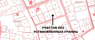
Land owners are constantly faced with incorrect display of boundaries on the cadastral map. The problem looks like this: the land plot is correctly registered in the cadastral register, but its location on the map differs from the real boundaries. Crossing borders and overlapping areas are observed in most holiday villages and rural settlements.
How errors occur
The cadastral map reflects the errors of participants in cadastral procedures. This happens when a cadastral engineer, land owner or Rosreestr employee makes an error in the coordinates. Rosreestr distinguishes two types of such errors.
Registry error
— the cadastral engineer entered incorrect coordinates into the original land survey plan and this erroneous information is registered in the Unified State Register of Real Estate.
In addition, Rosreestr employees may make technical errors.
, typos.
Then the correct coordinates from the boundary plan are distorted, and despite the reliability of the original documents, shifts in the corner points of the site occur on the cadastral map.
It happens that owners take mistakes
errors in satellite photography. And some are inclined to attribute their false ideas about boundaries to a mistake. It is important that in such situations, the USRN data corresponds to the legal state of affairs.
Correcting an error means making correct changes to the Unified State Register. There are two ways to make such changes: out of court and based on a court decision. The first method is distinguished by the absence of claims from third parties - owners of adjacent plots. If a conflict arises with neighbors, changes to the Unified State Register can be made by court decision. Let's look at standard situations.
Error 1. Distortion of the boundaries of one area
The owner of plot 54:07:054701:105 found out that on the Rosreestr map the boundaries of his plot overlapped with his neighbors’ plot: 348. It looks as if the problem area was turned counterclockwise.
The neighbors found out that they have no mutual claims regarding the actual boundaries. Here we can deal with a registration error by an engineer who incorrectly determined the coordinates of turning points on the ground and made a mistake when drawing up a boundary plan. If the engineer did everything correctly, then a technical failure occurred on the side of Rosreestr.
How to fix:
Let's mentally rotate the problem area clockwise. It will precisely lie on its actual boundaries, maintaining its area and configuration. The boundaries and area of adjacent plots remain unchanged. This means that the owners have no claims against each other. This fact determines the extrajudicial procedure for correcting the error.
If the engineer is wrong:
We do the surveying again.
To redo the project for free, we recommend contacting the cadastral engineer who made the mistake. The engineer can be brought to disciplinary liability, up to and including expulsion from the membership of the self-regulatory organization of cadastral engineers;
We send it to Rosreestr
updated boundary plan and statement of error correction. Documents are submitted through any MFC, since from January 1, 2021, Rosreestr does not accept citizens;
Rosreestr will correct the error
within 5 working days.
If you made a mistake in Rosreestr:
We submit an application to Rosreestr
through the MFC to correct an error in the USRN records;
Rosreestr will correct the error
within 3 working days.
Error2. Distortion of the boundaries of two or more areas
The owner in the center found out that his plot overlaps with the neighboring ones. The situation is complicated by the fact that the area adjacent to it is also displayed incorrectly on the map.
How to fix:
It's like a domino effect - you'll have to correct areas one by one. We will sequentially go through a chain of corrections of the boundaries of all sections, starting with section No. 2.
We are identifying all the victims
owners and agree on boundaries. The changes will not affect only the owner of plot No. 1;
We do land surveying
all problem areas again. It will be more convenient for everyone if the boundaries are assigned at the same time by a single contractor. You can try to eliminate the shortcomings at the expense of the person responsible for the original error;
We send it to Rosreestr
updated boundary plans along with statements about correcting the error. This can also be done by the surveyor;
Rosreestr will correct the error
within 5 working days.
Error 3. Refusal of the neighbor to agree on boundaries
Let's complicate the previous task. The owner of plot No. 8 does not agree to change the boundaries of his plot. He refused to sign the proposed act of border coordination. Perhaps he is satisfied with the erroneous configuration entered into the Unified State Register of Real Estate, and he insists on its authenticity. Rosreestr will refuse to register changes in the boundaries of all other areas.
How to fix:
will have to go to court. We demand that the information on the boundaries of the site of the dissenting owner be canceled due to a technical or registry error in the Unified State Register of Real Estate. Rosreestr can be involved as a third party. We enclose with the statement of claim: extracts from the Unified State Register for our own and adjacent plots, a copy of the boundary plan, confirmation of payment of the state duty.
After the court decision comes into force, we contact Rosreestr through the MFC. Attached are boundary plans and statements to clarify the boundaries of all plots.
Error 4. Shift of satellite photographs
A situation often encountered is when, when superimposing the coordinates of a cadastral map onto satellite photography, all areas
the blocks are equally shifted relative to their actual boundaries. It looks like this:
How to fix:
the shift is associated with errors in satellite photography, which Rosreestr has nothing to do with. Therefore, everything is in order with the site, the Unified State Register contains the correct data, which means there is no need to make changes. If you need an accurate image, simply move the card backing.
On the right, under the selection of satellite layers, there is a “Customize map” link. Click it and use the arrows to adjust the image until the borders align correctly:
Let us repeat that this is done only for your convenience and does not in any way affect the data in the Unified State Register of Real Estate.
Mistake 5. False boundaries
The owner of plot No. 2 is sure that his plot is displayed incorrectly on the cadastral map. He claims a larger area. Perhaps he even surrounded the area with a fence, and none of the neighbors voiced any complaints. There is no technical or registry error in the Unified State Register of Real Estate.
How to fix:
The public map displays everything correctly. We are faced with land squatting. It happens that, using the adjacent territory for a long time, the owners automatically attribute to themselves the “extra” acres.
This is illegal and is prosecuted administratively under Article 7.1 of the Code of Administrative Offenses of the Russian Federation. However, if the owner of plot No. 2 is confident that he is right, he will have to substantiate his claims in court.
In essence, we are talking about the legalization of squatting and the acquisition of another property.
Set the current owner
disputed area. Often this is a rural settlement or urban district. As a starting point we use Art. 11.7 of the Land Code of the Russian Federation “Redistribution of land plots”;
Be prepared for land surveying
and registration of the site for cadastral registration;
Document your reasons
your claims and contact the current owner pre-trial. Be prepared to justify your position in court;
If there is no confirmation
possession use art. 234 of the Civil Code of the Russian Federation on acquisitive prescription. Also consider purchasing a plot at auction.
Wrong boundaries need to be corrected
Judging by the requests from owners, displacement of cadastral boundaries is a frequent occurrence.
If you see an incorrect display of boundaries on the map, then the problem will have to be solved. Incorrect border coordinates are the cause of conflicts with neighbors. Such a plot is difficult to sell; legal construction cannot be carried out on it. There will also be difficulties with communications.
Source: https://egrp365.ru/info/chto-delat-esli-zemelnyj-uchastok-nepravilno-otobrazhyon-na-kadastrovoj-karte.html
How to correctly submit an application for amendments to the cadastral passport
- a copy of a Russian citizen’s passport or international passport;
- a copy of the power of attorney (if the procedure takes place with the participation of a representative);
- documents that can confirm ownership of a land plot (sale and purchase agreement, donation, exchange, certificate of inheritance, etc.);
- a completed application for amendments to the cadastral passport;
- documents that need to be amended (cadastral passport, boundary plan, government resolution on transferring land to another category).
On the appointed day, you should appear at the authority that carried out the procedure for making changes to the cadastral passport, present your passport and the issued receipt to receive the corrected documents, after which they should be transferred to Rosreestr. This completes the procedure.
Methods for changing information in the cadastre
How to make changes to the cadastral passport? This question most often arises before property owners. The procedure must be completed as quickly as possible, since there is a risk of being brought to administrative or even criminal liability due to violations resulting from inconsistency of information about real estate. That is why two main ways have been identified to make changes to the cadastre and register them. The first is to contact the cadastral service directly. In this case, you need to follow a few simple steps:
- Step one is collecting and preparing a package of documents. Their list is described in detail and always remains unchanged.
- Step two is submitting documents. It is carried out to the cadastral chamber, in person or through a representative. This body must make decisions based on the submitted papers.
- Step three – payment of the state fee. It is three hundred rubles according to the law, but may depend on the size of the property.
- Step four – obtaining a cadastral passport. The day on which you need to appear for the document will be indicated in the receipt issued when submitting the papers.
- Step five – registration. The changes made need to be actually fixed; to do this, it is enough to submit an application to Rosreestr. In this case, you will also need to pay a state fee. It is two hundred rubles for citizens, six hundred rubles for organizations. Registration takes no longer than ten working days.
In addition to personally transmitting documents to the cadastral service, it is possible to submit a package of documents by using the Rosreestr website, which provides an electronic version of the procedure for submitting papers to change the cadastral passport. Several sequential actions are defined here:
- Step one - documents. Just like when submitting in person, you need to prepare them in advance, only in addition to collecting everything you need, the papers should be scanned to be uploaded to an electronic resource.
- Step two - state duty. It is also paid in the amount of three hundred rubles, and the receipt is scanned along with all documents.
- Step three – registration on the site. After this procedure, it is enough to select the command for making changes to the passport and start working.
- Step four – filling out the form. We are talking about a statement that is similar to a written version. At this stage, the entire package of documents is also attached by placing their scanned versions.
- Step five - notification. The site will notify the user by email that the documents have been accepted and will be reviewed within a certain period of time.
You can only receive a cadastral passport in person or through an intermediary. In addition, even when using an electronic resource, it will be necessary to register changes made.