Land Code actual land use
Preparation of land surveying projects is carried out as part of territory planning projects or as a separate document.
4. The sizes of land plots within the boundaries of built-up territories are established taking into account the actual land use and urban planning standards and rules that were in force during the development of these territories. If, in the process of land surveying, land plots are identified whose dimensions exceed the maximum (minimum and (or) maximum) sizes of land plots established by the town planning regulations, land plots formed on the basis of the identified plots are provided for construction, provided that their sizes comply with the town planning regulations.
5.
Fines for misuse of land
The Administrative Code provides for fines, the amount of which varies from 2 thousand to 700 thousand rubles. The amount depends on the following factors:
- Category of the offender (individual, individual entrepreneur or organization).
- Category of land and its purpose.
- Square.
- Cadastral value.
Let us recall that the cadastral value (CV) differs significantly from the market value, and it can only be determined by a representative of a budgetary institution established in each constituent entity of the Russian Federation.
You can find out the CS directly from Rosreestr by ordering the corresponding extract from the Unified State Register of Real Estate, as well as on the website of the Cadastral Chamber, using the electronic service “Extract from the Unified State Register of Cadastral Value” or a public map. For the last 2 options, you need to know the cadastral number of the plot and fill in the required fields.
*All about the cadastral value: why it is important to know it and how to achieve a revision, read here.
The amount of the fine for areas with CC is calculated as a percentage, the minimum is 0.1%, and the maximum is 10%. And if the KS is not determined, then you will have to pay a fixed amount assigned by an authorized person.
Example
Ivanov owns a land plot intended for the construction of an individual house. However, for 7 years he did not take any actions aimed at the intended use of the site.
According to Art. 8.8 of the Code of Administrative Offenses of the Russian Federation, the amount of the fine is 1-1.5% of the CC, but not less than 20 thousand rubles, and if the CC is not determined - from 20 thousand rubles. up to 50 t.r.
If the KS is, for example, 350,000 rubles. then the fine according to the percentage will be from 3,500 to 5,250 rubles. But it cannot be less than 20 thousand rubles.
Thus, Ivanov must pay a fine of 20 thousand rubles.
Land management examination
Below we will look at what they are.
In accordance with paragraph 2 of Art. 26 of Federal Law No. 221-FZ of July 24, 2007 “On the State Real Estate Cadastre” (hereinafter referred to as the Law on the State Property Committee No. 221-FZ), cadastral registration is suspended if one of the boundaries of the site for which an application for cadastral registration is submitted crosses (overlaps) one from the boundaries of another land plot, information about which is contained in the state real estate cadastre (an exception is the case if the other land plot is a converted real estate object).
Litigation over land boundaries
Law enforcement practice in recent years indicates that the category of cases included in the title of this article is increasingly encountered in judicial practice. According to the observations of the author of the article, this is due, first of all, to the fact that the owners of land plots, under the influence of the requirements of state and municipal land authorities, began to increasingly clarify the boundaries of their possessions and put their land documentation in order. This work leads to the fact that owners and property owners (often to their amazement) learn about overlaps in the boundaries of land plots on maps (diagrams) and on the ground, about cadastral errors, about the location of their real estate within “foreign” borders, etc.
Without pretending to be a comprehensive study within the framework of a newspaper article, we will try to highlight some problematic issues that arise in this category of disputes and formulate practical conclusions. This can help novice lawyers, among other things, find the right approaches to resolving these disputes.
Due to the already established judicial practice in accordance with Article 7 of the previously valid version of the Federal Law of July 24, 2007 N 221FZ “On the State Real Estate Cadastre” (from January 1, 2021, the state cadastral registration of real estate is carried out in the manner established by the Federal Law of July 13, 2015 No. 218 -FZ (as amended on August 3, 2018) “On State Registration of Real Estate”, and Law No. 221-FZ itself is called the Law “On Cadastral Activities”), the unique characteristics of a land plot include its cadastral number, description of the location of boundaries and area.
Thus, entering into the Unified State Register of Real Estate information about changes in the area and (or) boundaries of a land plot due to adjustments in the location of its borders (turning points) essentially represents the disposal of this plot, as a result of which ownership and other derivative real rights to the site in its previous form, determined by a set of unique characteristics, ceases to exist.
The registered right to real estate can only be challenged in court. Since in such a challenge the court resolves a dispute about civil rights to real estate, the corresponding claims are considered in the manner of claim proceedings (paragraph 52 of the resolution of the Plenum of the Supreme Court of the Russian Federation No. 10 and the Plenum of the Supreme Arbitration Court of the Russian Federation No. 22 dated 04/29/2010 “On some issues arising in judicial practice when resolving disputes related to the protection of property rights and other property rights”).
In accordance with paragraph 3 of paragraph 2 of the same resolution of the Plenum of the Supreme Court of the Russian Federation No. 10 and the Plenum of the Supreme Arbitration Court of the Russian Federation No. 22 dated April 29, 2010, claims for rights to real estate include, in particular, claims for establishing the boundaries of a land plot.
In this case, the interested person has the right to apply to the arbitration court with a claim aimed at changing the boundaries of a land plot already registered in the cadastral register (Resolution of the Presidium of the Supreme Arbitration Court of the Russian Federation dated September 6, 2011 No. 4275/11).
According to the legal position formulated in the ruling of the Supreme Court of the Russian Federation dated October 7, 2015 No. 305-KG15-7535 in case No. A41-47432/2012, when the subject of the dispute is related to the intersection (overlapping) of land plots, information about the boundaries of one of which is included in state real estate cadastre, and the other is subject to clarification, then the applicant’s requirements in this case are subject to consideration according to the rules of claim proceedings as a requirement to establish the boundaries of the land plot.
Thus, the requirement to establish the location of the boundaries of a land plot is a dispute of law.
The requirement to establish the boundaries of a land plot is aimed at eliminating uncertainty in the location of the boundary of a land plot and resolving a dispute about the ownership of one or another part of it. The court decision that established the boundaries of a land plot is the basis for changing information about this land plot in the Unified State Register of Real Estate. In such claims, the defendant is the adjacent land user, since within the framework of the stated claim, an adjacent boundary between land plots must be established in accordance with the established coordinates of the turning points.
The legal positions presented here, formulated by established judicial practice, immediately allow us to draw certain primary conclusions when resolving disputes about the boundaries of land plots:
·
Disputes of this kind are considered according to the rules of claim proceedings, since the requirement to establish the location of the boundaries of a land plot is a dispute about law;
·
The issue of establishing (changing) the boundaries of land plots formed and registered in the cadastral register is within the competence of the court. The court may change such boundaries in accordance with the procedure established by law;
·
A court decision that established the boundaries of a land plot is the basis for changing information about this land plot in the Unified State Register of Real Estate;
·
In claims for establishing (changing) adjacent boundaries between land plots, the defendants are adjacent land users.
According to paragraphs 1 and 2 of Art. 43 of the Federal Law of July 13, 2015 No. 218-FZ (as amended on August 3, 2018) “On State Registration of Real Estate” state cadastral registration in connection with a change in the description of the location of the boundaries of a land plot and (or) its area, with the exception of cases of formation of a land plot when separating from a land plot or dividing a land plot, in which the converted land plot remains within the changed boundaries, it is carried out provided that such changes are associated with clarification of the description of the location of the boundaries of the land plot, about which the information contained in the Unified State Register of Real Estate does not correspond to the established ones on the basis of the specified Federal Law, the requirements for describing the location of the boundaries of land plots (hereinafter referred to as clarification of the boundaries of the land plot).
If, during state cadastral registration, in connection with clarifying the location of part of the boundaries of a land plot, which is also a common (adjacent) part of the boundaries of other land plots, and (or) a change in the area of the land plot, changes are required to the information contained in the Unified State Register of Real Estate, land plots adjacent to it, the rights registration authority, simultaneously with the implementation of state cadastral registration, makes appropriate changes to the information contained in the Unified State Register of Real Estate on the location of the borders (parts of the borders) and the area of these adjacent land plots. In this case, the submission of additional applications for state cadastral registration of changes in the information contained in the Unified State Register of Real Estate in relation to the specified adjacent land plots is not required. In this case, the location of the boundaries of the land plots is considered agreed upon only if the act of agreeing on the location of the boundaries contains personal signatures of all interested persons or their representatives.
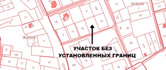
A land plot is recognized as a part of the earth's surface that has characteristics that make it possible to define it as an individually defined thing (clause 3 of Article 6 of the Land Code of the Russian Federation; Part 8 of Article 22 of Law No. 218-FZ).
Boundaries are the main individualizing feature of a land plot and are determined when performing cadastral survey work (Part 2 of Article 8 of Law No. 218-FZ).
In accordance with Part 8 of Article 22 of Law No. 218-FZ, the location of the boundaries of a land plot is established by determining the coordinates of the characteristic points of such boundaries, that is, the points of change in the description of the boundaries of the land plot and dividing them into parts.
In accordance with Article 21 of Law No. 218-FZ, one of the necessary documents for cadastral registration is a boundary plan (when registering a land plot, registering a part of a land plot or cadastral registration in connection with a change in the unique characteristics of a land plot), as well as a copy of the document, confirming the resolution of a land dispute on the approval of the location of the boundaries of a land plot in the manner established by land legislation (if, in accordance with Article 38 of the same Federal Law, the location of such boundaries is subject to mandatory approval and the boundary plan submitted taking into account this paragraph does not contain information about the agreement on the location of such boundaries) .
In accordance with Part 1 of Article 22 of Law No. 218-FZ, a boundary plan is a document that is drawn up on the basis of a cadastral plan of the relevant territory or an extract from the Unified State Register of Real Estate about the relevant land plot and in which certain information entered in the Unified State Register of Real Estate is reproduced , and information about the land plot or land plots being formed, or about a part or parts of the land plot, or new information about the land plot or land plots necessary for entering into the Unified State Register of Real Estate is indicated.
According to Part 7 of Article 36 of the Land Code of the Russian Federation, the location of the boundaries of a land plot and its area are determined taking into account actual land use in accordance with the requirements of land and town planning legislation. The location of the boundaries of the land plot is determined taking into account the red lines, the location of the boundaries of adjacent land plots (if any), and the natural boundaries of the land plot.
Part 10 of Article 22 of the Federal Law of July 13, 2015 No. 218-FZ “On State Registration of Real Estate” establishes that when clarifying the boundaries of a land plot, their location is determined based on the information contained in the document confirming the right to the land plot, or in the absence such a document from the information contained in the documents that determined the location of the boundaries of the land plot when it was formed. If the documents specified in this part are missing, the boundaries of the land plot are the boundaries that have existed on the ground for fifteen years or more and are fixed using natural objects or objects of artificial origin that make it possible to determine the location of the boundaries of the land plot.
From the above, we can also formulate some conclusions that are important for understanding the procedure for resolving legal disputes about boundaries (let’s call them this for brevity):
·
Clarification of the boundaries of land plots can be carried out out of court (with the consent of adjacent land users and the absence of a dispute);
·
A boundary plan formed based on the results of cadastral work is an inevitable attribute of a boundary claim. Without the information contained in it, the court simply will not be able to formulate the operative part of its decision on boundaries. In some judicial acts, the author of the publication even saw that the boundary plan was an annex to the court decision. An alternative to the boundary plan can only be the conclusion of a forensic land survey conducted by the court;
·
The location of the boundaries of a land plot in a court decision is established by determining the coordinates of characteristic points of such boundaries (the so-called turning points);
·
When issuing judicial acts, the courts are not bound by the border options proposed by the parties to the dispute. The court can set boundaries according to its own version, taking into account the maximum balance of interests of the parties. Such border options should be determined based on the results of cadastral work or the results of a forensic land management examination.
(Ends in No. 02.2019)
MIKHAIL SLEPTSOV
, ATTORNEY, MANAGING PARTNER OF THE LAW OFFICE "SLEPTSOV AND PARTNERS", CANDIDATE OF LAW, ASSOCIATE PROFESSOR, HONORED LAWYER OF THE RUSSIAN FEDERATION
Source of publication: information monthly “The Right Decision” issue No. 01 (195) release date of 01/21/2019.
The article was posted on the basis of an agreement dated October 20, 2016, concluded with the founder and publisher of the information monthly “Vernoe Reshenie” LLC “.
Article 48
the claim was denied.
By a ruling of the Court of Appeal dated February 27, 2006, the decision of October 26, 2005 was overturned and the claim was satisfied.
In the cassation appeal, JSC “A” asked to cancel the decision of the court of appeal and uphold the decision of the court of first instance, citing the violation by the court of appeal of the rules of substantive law, the discrepancy between the conclusions of the court of appeal and the actual circumstances of the case and the evidence available in the case.
As follows from the case materials, by Order of the Committee on Urban Planning and Architecture of the Administration of St. Petersburg (hereinafter referred to as the CGA) dated May 21, 1997.
How to avoid fines for misuse of land?
To prevent the land inspector from issuing a fine to you, you must always comply with the norms prescribed by law:
- Use the site for its intended purpose or promptly transfer it to another category;
- When exploiting the land, do not harm nature and the environment;
- On agricultural land, mow the grass or carry out other permitted activities at least once every 3 years.
If you need the help of qualified engineers to transfer your plot from one category of land to another, to resolve issues related to the misuse of land, then leave a request on the website of the Central Cadastral Bureau. We will contact you as soon as possible, answer your questions and solve your problems.
Ulyanovsk region
A plot of land under a residential building is provided free of charge to citizens for one-time ownership.
3. The provisions of Part 1 of this article do not apply to cases where the rights to the corresponding and (or) residential buildings located on them can be registered as the property of citizens in accordance with the Federal Law of June 30, 2006 No. 93-FZ “On Amendments to Some legislative acts of the Russian Federation on the issue of registration in a simplified manner of citizens’ rights to certain real estate objects”, Article 39 20 of the Code of the Russian Federation, Part 9 1 Article 3 of the Federal Law of October 25, 2001 No. 137-FZ “On the implementation of the Land Code of the Russian Federation” Federation", other federal laws.
1.
Application to establish the fact of possession and use
The applicant's husband was accepted into the gardening partnership and was given a plot of land. On this plot of land he built a house in which they lived. The applicant's husband died. During his lifetime, he did not have time to formalize his ownership of the land and residential building. Without establishing the legal fact of ownership and use by the husband of a land plot and house ownership on the right of personal ownership, it is not possible for the applicant, as a first-degree heir, to accept the inheritance after the death of her husband.